")

Download Maps
Download Google Earth Maps
* You must have the Google Earth app in order to view the above files
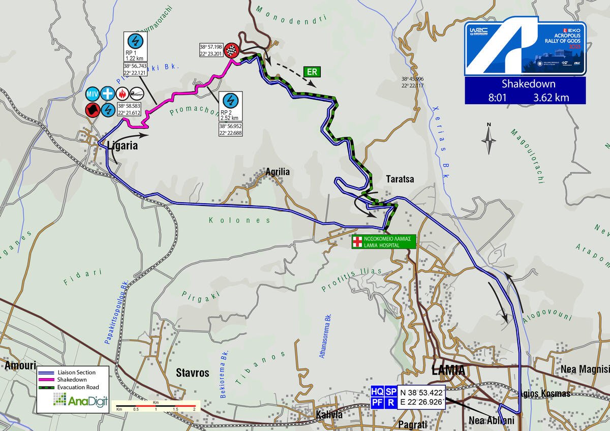
THURSDAY 26 JUNE 2025
SHAKEDOWN
Length: 3.62 km
Road closing time: 06:30
First car due: 08:01
NO TAPE, NO PUBLIC
Under the FIA safety regulations, areas without safety nets, fencing, or tape are prohibited. Find your spot only in the designated areas marked with safety precautions or elevated spots.
INFO: Please ensure you arrive at your spot at least 30 minutes before the first competitive car starts. After that time, walking or moving on the special stage, including the start and stop, will be prohibited.
DESCRIPTION:
Representative of the rally’s stages, the first part of the Shakedown is fast with technical corners, despite being on a hard surface. As the road climbs, it widens while maintaining its technical and fast character.
SPECTATOR ACCESS
Since there is no intermediate access to the Shakedown, pedestrian entry from the finish area will be allowed no later than 07:15. Before that time, please park along the Lamia-Domokos road, following the directives of the Hellenic Police and the event organisers.
Click to navigate
SHAKEDOWN FINISH
FRIDAY 27 JUNE 2025
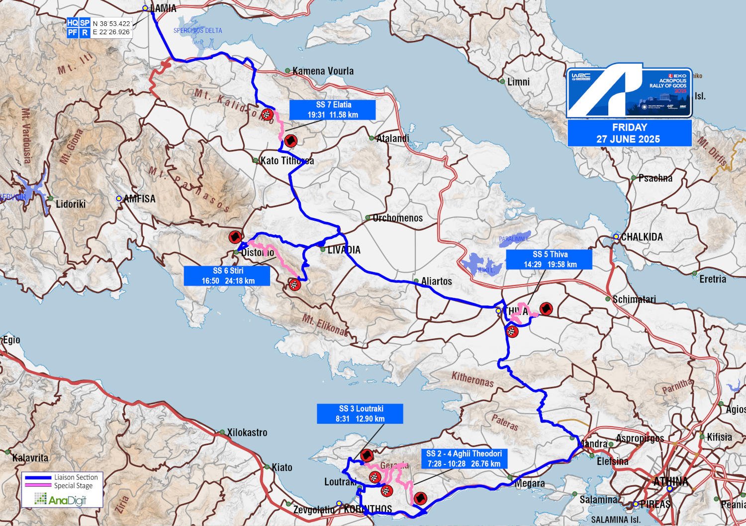
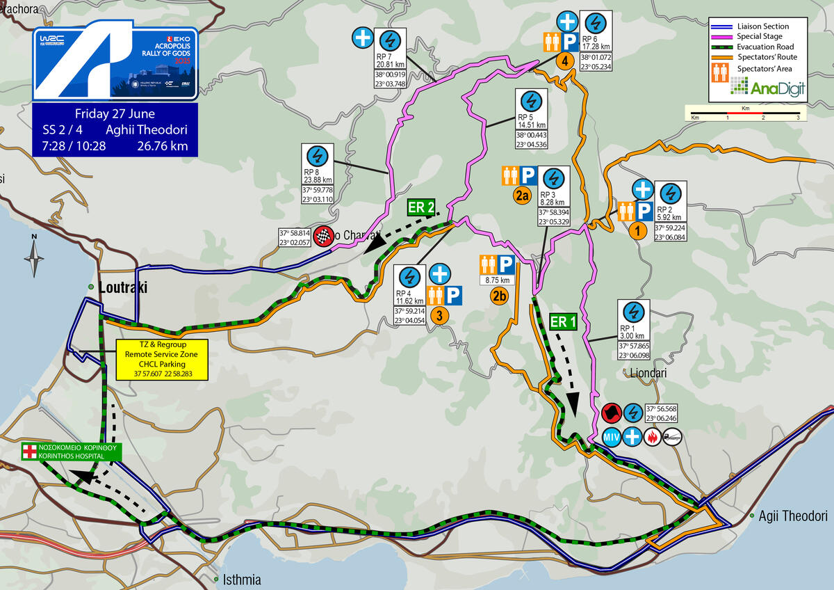
SS 2 - 4 AGHII THEODORI
Length: 26.76 km
Timetable
Road closing time: 04:28
First car due: SS 2 07:28
SS 4 10:28
NO TAPE, NO PUBLIC
Under the FIA safety regulations, areas without safety nets, fencing, or tape are prohibited. Find your spot only in the designated areas marked with safety precautions or in elevated spots.
INFO: Select your viewing point at least 30 minutes prior to the start of the special stage. After this time, no movement will be permitted on the road, including the start and finish areas.
Access points are divided into three categories based on the difficulty of the road surface. The category letter is displayed in bold next to each access number.
The categories are:
• S = Soft = Passenger car
• M = Medium = SUV
• H = Hard = 4x4 or Enduro motorcycle
DESCRIPTION
Starting from the beginning of the gravel road, on the right at the junction where the road straight ahead leads to the settlement of Kiafa Beka, the stage transitions to tarmac after approximately 7 km. After a further 1.3 km, it makes a sharp right turn onto the familiar section with 3A, heading towards the small chapel of Panagia tou Prathi. From there, it continues left into a very narrow and downhill stretch, 3.60 km long, leading to the river.
The route then continues, either crossing the river or through its riverbed, for the remaining 6.00 km, finishing at the settlement of Kato Charvati.
SPECTATOR ACCESS
1 (H)
Driving on the Athens–Corinth National Road towards Corinth, take the exit for Kineta. At the following junction, turn right towards “Galini”. At the T-junction, turn left, and after 450 m, at the next T-junction with several signs on a fence, reset your trip meter and turn right into the narrow road (Geranion Street) heading towards Agios Nikolaos.
After 1.5 km, at a fork with a sign for “Mary’s Guesthouse” on a utility pole, take the right-hand road, continuing on Geranion Street. At a junction 150 m later, turn right.
After 1.2 km, continue straight onto a rough dirt road. At 1.3 km, ignore the road on the right and keep going straight.
After 5.7 km, turn left and follow the wide dirt road, which also passes a fire safety point. After 3.9 km, you will reach the 5.92 km of the special stage.
Click to navigate
SS 2-4 AGHII THEODORI ACCESS 1 (5.92km)
2
The initial directions are common to both access roads.
Driving on the Athens–Corinth National Road towards Corinth, take the exit for Agioi Theodoroi. After 360 m, you will pass a toll station. Then, after 170 m, at the STOP sign, turn left, and after 1.73 km (just before the railway tracks), turn sharply left again onto the first road.
After 580 m, having passed two roads on your right, turn slightly left. Then, after 220 m (having passed under the second bridge), turn left again. After another 180 m, turn right onto a narrow uphill road heading to “Kiafa Beka”.
After 2.77 km, pass the junction with a gravel road on your right, where the start of the special stage is located.
Attention: If you wish to access the start of the stage (at least 30 min before the start), park after the junction, as the space before the gravel road is reserved as the holding area of the rally cars.
From this point, you have two options:
2a (S)
After 2.3 km, ignore the gravel road on your left and continue on the tarmac for another 2.5 km.
Park according to the marshals’ instructions.
A short walk will take you to the 8.28 km of the special stage.
Attention: This road serves as an ambulance emergency exit. It must remain clear at all times.
Blocking the escape route may result in the cancellation of the special stage.
Click to navigate
SS 2-4 AGHII THEODORI ACCESS 2a (8.28km)
2b (Μ)
After 2.3 km, turn left onto a gravel road. After 1.7 km, turn right uphill. Follow the road along the firebreak, and after 2.6 km, you will reach the 9.34 km of the special stage.
Click to navigate
SS 2-4 AGHII THEODORI ACCESS 2b (9.34km)
3 (S)
On the main road from the Isthmus towards Loutraki, turn right onto Karantani Street, right by the PepsiCo–Ivi factory.
After 4.9 km, you’ll reach a junction with a sign reading “NEA POLITEIA – Welcome” and turn right towards the small chapel of the Metamorfosi tou Sotiros (Transfiguration of the Savior).
At this point, the surface becomes gravel.
Continue on the gravel road for 4.7 km, reaching the 11.62 km of the special stage.
Attention: This road serves as an ambulance emergency exit. It must remain clear at all times.
Blocking the escape route may result in the cancellation of the special stage.
Click to navigate
SS 2-4 AGHII THEODORI ACCESS 3 (11.62km)
4 (Η-Μ)
By following the access instructions 1a and reaching the 5.3 km of the special stage, turn right and follow the uphill gravel road for 5.5 km to arrive at the Monastery of Panagia tou Prathi, as well as the 17.28 km of the special stage.
Click to navigate
SS 2-4 AGHII THEODORI ACCESS 4 (17.28km)
FRIDAY 27 JUNE 2025
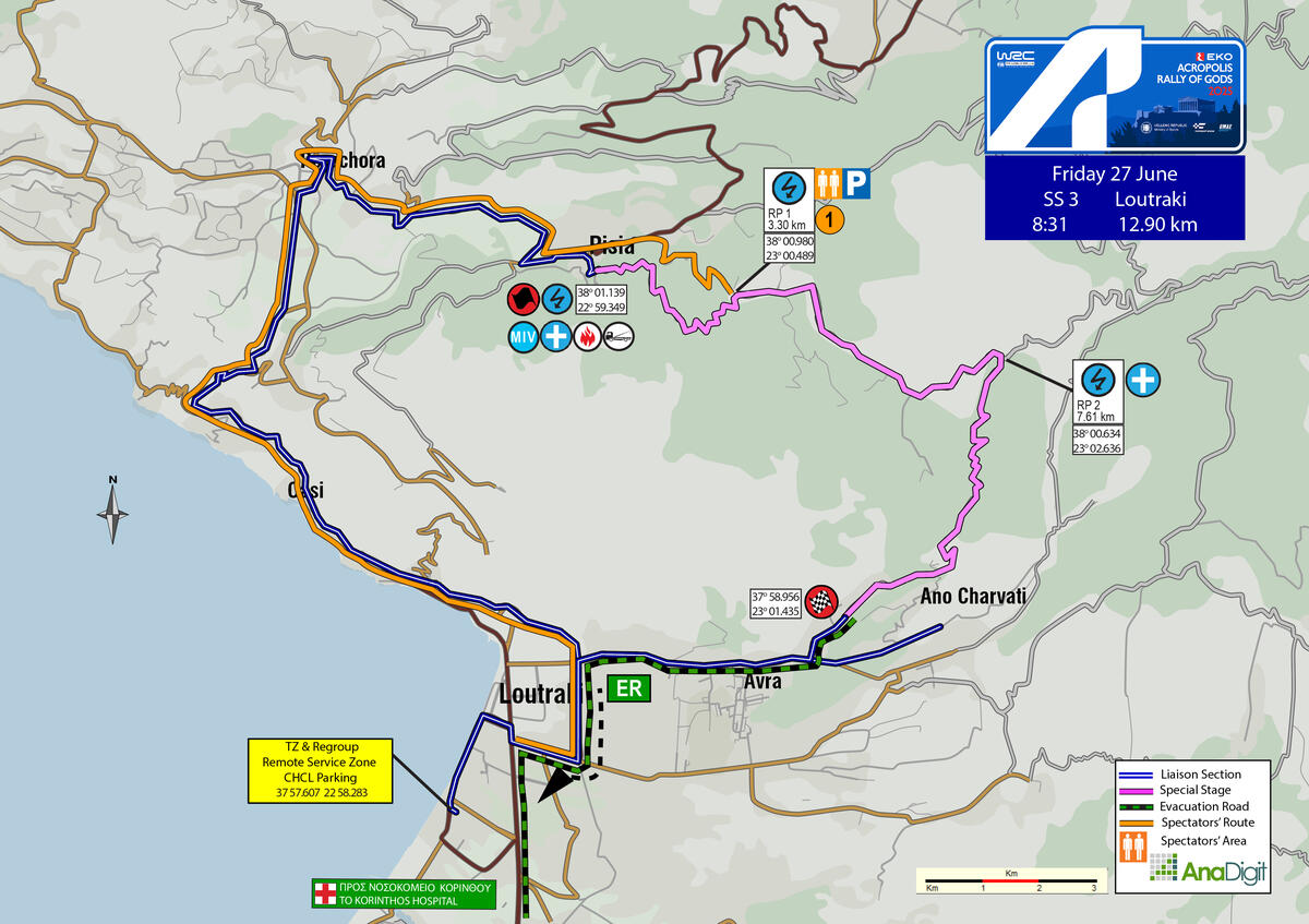
SS 3 LOUTRAKI
Length: 12.90 km
Timetable
Road closing time: 05:31
First car due: 08:31
NO TAPE, NO PUBLIC
Under the FIA safety regulations, areas without safety nets, fencing, or tape are prohibited. Find your spot only in the designated areas marked with safety precautions or in elevated spots.
INFO: Select your viewing point at least 30 minutes prior to the start of the special stage. After this time, no movement will be permitted on the road, including the start and finish areas.
Access points are divided into three categories based on the difficulty of the road surface. The category letter is displayed in bold next to each access number.
The categories are:
• S = Soft = Passenger car
• M = Medium = SUV
• H = Hard = 4x4 or Enduro motorcycle
DESCRIPTION
It begins with a narrow uphill section, 3.30 km long, starting from the “Platanos” restaurant in Pisia and reaching the church of Panagia Faneromeni. Next comes a very fast downhill section, 4.30 km long. The stage then transitions into a steep and highly technical downhill part, approximately 5.00 km in length, before finishing at the first houses of the Ano Charvati settlement.
SPECTATOR ACCESS
1 (M)
In Loutraki, at the PepsiCo-Ivi factory, turn right onto Karantani Street. After 800 meters, turn left and follow the Loutraki ring road. After 16 km, you’ll reach the village of Pisia; continue towards Schinos. After 0.9 km, turn right onto a narrow uphill road. Drive for another 2.1 km to reach the 3.3 km of the special stage, at the location of the Panagia Faneromeni church.
Click to navigate
SS 3 LOUTRAKI ACCESS 1 (3.30km)
FRIDAY 27 JUNE 2025
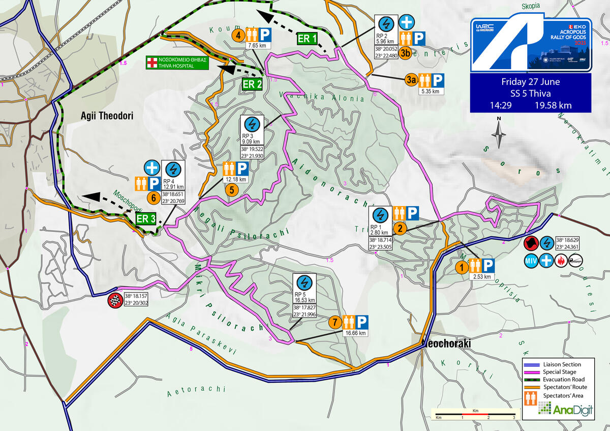
SS 5 THIVA
Length: 19.58 km
Stage closure: 11:29
First car due: 14:29
NO TAPE, NO PUBLIC
Under the FIA safety regulations, areas without safety nets, fencing, or tape are prohibited. Find your spot only in the designated areas marked with safety precautions or in elevated spots.
INFO: Select your viewing point at least 30 minutes prior to the start of the special stage. After this time, no movement will be permitted on the road, including the start and finish areas.
Access points are divided into three categories based on the difficulty of the road surface. The category letter is displayed in bold next to each access number.
The categories are:
• S = Soft = Passenger car
• M = Medium = SUV
• H = Hard = 4x4 or Enduro motorcycle
DESCRIPTION
This year’s Thiva stage is a blend of classic lines from previous editions, covering a total of 19.58 km. The stage maintains its signature rhythm, featuring big jumps, tight and technical sections on predominantly soft surfaces, and fast stretches where commitment and clean lines make the difference.
SPECTATOR ACCESS
1 (S)
Follow the Neochoraki–Schimatari provincial road and pass through the village of Neochoraki, heading towards Asopia. Reset your trip meter at the point where you’ll see a yellow warehouse with fencing on your left. Ignore the gravel road on your left (500 m) and at 700 m, turn left onto an uphill concrete road. In 40 m, the surface becomes gravel - ignore the gravel road on your left. At the next fork, keep left. Continue for another 450 m and turn right onto a dirt road, where you can park. From there, walk approximately 80 metres to reach the spectacular jump located at the 2.53 km of the special stage.
Click to navigate
SS 5 THIVA ACCESS 1 (2.53km)
2 (S)
Drive along the Neochoraki–Schimatari provincial road, passing through the village of Neochoraki in the direction of Asopia. Reset your trip meter at the point where you’ll see a yellow fenced warehouse on your left. After 500 m, turn left onto a well-maintained gravel road. Continue for 450 m to reach the 2.80 km of the special stage.
Click to navigate
SS 5 THIVA ACCESS 2 (2.80km)
3a (H)
From the Thiva–Chalkida provincial road, turn at the junction towards Jumbo Thiva. Reset your trip meter at this point. Continue on the tarmac road for 600 metres, passing a gravel road on your left and then immediately another on your right, with a sign “ΧΥΤΑ Θήβας” - turn left there. After 500 m, you’ll reach the entrance of the landfill and a sign “Υπουργείο Περιβάλλοντος και Ενέργειας”. At the start of the fenced area, turn right onto a rough uphill gravel road. After 1.23 km, you will reach the 5.35 km of the special stage.
Click to navigate
SS 5 THIVA ACCESS 3a (5.35km)
3b (M)
From the Thiva–Chalkida provincial road, turn at the junction towards Jumbo Thiva. Reset your trip meter at this point and continue for 600 m on the tarmac. You’ll pass a gravel road on your left, followed immediately by another on your right, with a sign “ΧΥΤΑ Θήβας”, where you continue with a left-hand bend. After 200 m, you’ll find a moderate-quality uphill gravel road on your right. Park along the first 400 m, on one side only, and facing the direction of departure. From there, continue on foot for 300 m to reach the 5.96 km of the special stage.
Attention: This road serves as an ambulance emergency exit. It must remain clear at all times. Blocking the escape route may result in the cancellation of the special stage.
Click to navigate
SS 5 THIVA ACCESS 3b (5.96km)
4 (S)
From the Thiva–Chalkida provincial road, take the exit towards the Thiva Hospital. Continue straight for 850 m and park according to the organisers’ instructions. From the junction, walk straight ahead on a dirt road for approximately 550 m to reach the 7.65 km of the special stage.
Attention: This road serves as an ambulance emergency exit. It must remain clear at all times. Blocking the escape route may result in the cancellation of the special stage.
Click to navigate
SS 4 THIVA ACCESS 4 (7.65km)
5 (S-M)
From the Thiva–Chalkida provincial road, take the exit towards Thiva Hospital. Continue straight and, at 850 m, turn right onto an uphill dirt road. Follow the wide gravel road for 1.7 km. At the next fork, turn right again, and after 900 m, you’ll reach the 12.18 km of the special stage.
Click to navigate
SS 5 THIVA ACCESS 5 (12.18km)
6 (S)
Approaching from either direction on Oplarchigou Vogli Street, turn at the intersection where the Church of Evangelist Loukas is located, following signs for Moschopodi / Forest Service / Thiva Cemetery. After 700 m, pass the Forest Service building and continue towards the Moschopodi Theatre. At 800 m, turn right at the junction towards the CASTELLO country club. After another 400 m, park in the open area, following the marshals’ instructions. From there, walk uphill on a gravel road for approximately 450 m to reach the 12.91 km of the special stage.
Attention: This road serves as an ambulance emergency exit. It must remain clear at all times. Blocking the escape route may result in the cancellation of the special stage.
Click to navigate
SS 5 THIVA ACCESS 6 (12.91km)
7 (S)
Approaching from either Thiva or Erythres, turn at the junction towards the village of Neochoraki, where you should reset your trip meter. Continue on the Neochoraki–Schimatari provincial road, and after 4.9 km, turn left onto a good gravel road, at the point where the Traffic Education Park fencing begins. At the first fork, take the left-hand road, which leads you, after 950 m, to the 16.66 km of the special stage.
Click to navigate
SS 5 THIVA ACCESS 7 (16.66km)
FRIDAY 27 JUNE 2025
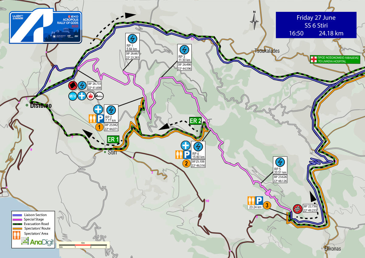
SS 6 STIRI
Length: 24.18 km
Stage closure: 13:50
First car due: 16:50
NO TAPE, NO PUBLIC
Under the FIA safety regulations, areas without safety nets, fencing, or tape are prohibited. Find your spot only in the designated areas marked with safety precautions or in elevated spots.
INFO: Select your viewing point at least 30 minutes prior to the start of the special stage. After this time, no movement will be permitted on the road, including the start and finish areas.
Access points are divided into three categories based on the difficulty of the road surface. The category letter is displayed in bold next to each access number.
The categories are:
• S = Soft = Passenger car
• M = Medium = SUV
• H = Hard = 4x4 or Enduro motorcycle
DESCRIPTION
The stage begins just outside Distomo. The first 8.93 kilometres are arguably the most spectacular of the entire rally! Mostly uphill and fast, this section features very wide roads and third-gear hairpins - a guaranteed recipe for significant action. It is followed by a forested stretch of roughly 9 kilometres, leading to a narrower downhill part with hairpins, cutting through quarry terrain, to the finish on the Elikonas plateau.
SPECTATOR ACCESS
INFO: Access to the first kilometers of the special stage from the start will be closed 1 hour and 30 minutes before the start, as the road will be blocked with barriers and pedestrian access toward the wind turbines will not be allowed. After the closure, only safety cars will be permitted to enter.
1 (M)
Coming from Distomo, you reach the village of Stiri, where you reset your trip meter at the monument in Agios Nikolaos square. Continue on the Distomo–Οsios Loukas road, heading towards Kyriaki. After 600 m, with a church on your left, turn left onto a downhill tarmac road. At the next fork, where you see a yellow sign for “Osios Symeon”, take the right-hand road. After 300 m, at a junction with a white roadside shrine, go diagonally left onto a concrete road. At 800 m, the surface changes to gravel. At 1.5 km, ignore the uphill road on the right (access 2) and continue straight. After 1.2 km, at a junction, turn back right. After another 900 m, you’ll reach a junction where you park on the left-hand road. From there, a 100 m walk will take you to the 7.77 km of the special stage.
Click to navigate
SS 6 STIRI ACCESS 1 (7.77km)
2 (M)
Coming from Distomo, you reach the village of Steiri, where you reset your trip meter at the monument in Agios Nikolaos square. Continue on the Distomo–Οsios Loukas road, heading towards Kyriaki. After 600 m, with a church on your left, turn left onto a downhill tarmac road. At the next fork, where there’s a yellow sign for “Osios Symeon”, take the right-hand road. After 300 m, at a junction with a white roadside shrine, go diagonally left onto a concrete road. At 800 m, the surface changes to gravel. At 1.5 km, turn back right onto an uphill road. After 450 m, at a fork, take the left-hand road. After 4.90 km, you’ll reach the 15.60 km of the special stage.
Click to navigate
SS 6 STIRI ACCESS 2 (15.60km)
3 (M)
Driving from Livadia towards Kyriaki, you reach the junction for Elikonas, where you reset your trip meter. After 2.3 km, you pass the STOP point of the special stage on your right. After another 740 m, at a left-hand bend with the start of a guardrail and a reversed STOP sign, turn right onto an uphill gravel road. After 500 m, you’ll reach the 23.24 km of the special stage.
Click to navigate
SS 6 STIRI ACCESS 3(23.24km)
FRIDAY 27 JUNE 2025
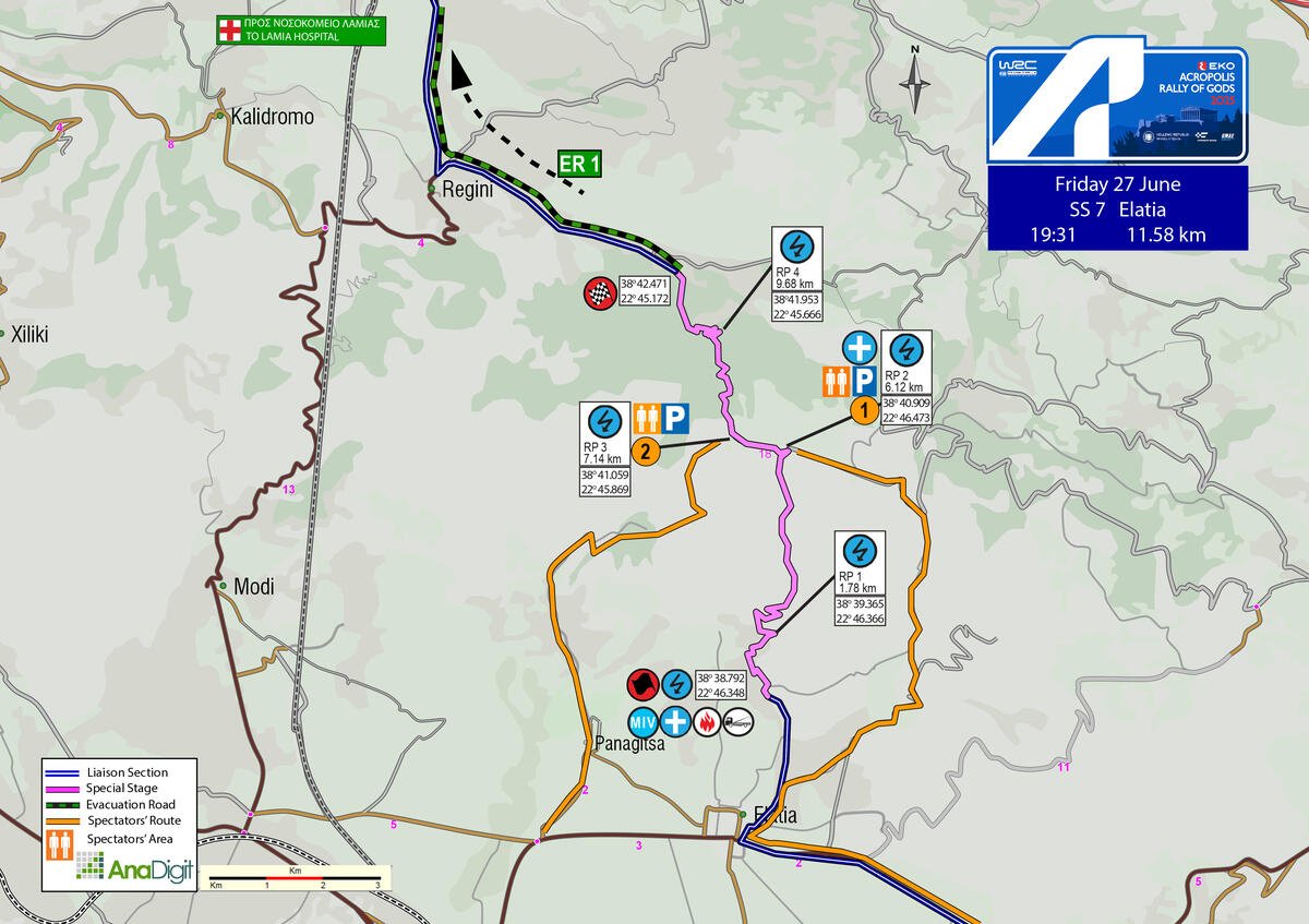
SS 7 ELATIA
Length: 11.58 km
Timetable
Road closing time: 16:31
First car due: 19:31
NO TAPE, NO PUBLIC
Under the FIA safety regulations, areas without safety nets, fencing, or tape are prohibited. Find your spot only in the designated areas marked with safety precautions or in elevated spots.
INFO: Select your viewing point at least 30 minutes prior to the start of the special stage. After this time, no movement will be permitted on the road, including the start and finish areas.
Access points are divided into three categories based on the difficulty of the road surface. The category letter is displayed in bold next to each access number.
The categories are:
• S = Soft = Passenger car
• M = Medium = SUV
• H = Hard = 4x4 or Enduro motorcycle
DESCRIPTION
This is the Elatia-Rengini version, used in 2022. It starts just before the archaeological site above the village of Elatia, before the tarmac ends, heading towards Vasilika.
The stage ascends with hairpin turns up to 4.50 km, where the fast downhill section begins, passing in front of the Moto-Cross track. At 6.12 km, the route takes a left turn, and after 0.73 km, it passes by the famous Elatia water splash at 6.86 km.
The final downhill section, which features hairpin turns, leads to the finish by the church.
Attention: Due to the narrow width of the road in both directions, the road will be closed for at least 3.50 km from Elatia (start) to Rengini (finish).
SPECTATOR ACCESS
1 (Μ-H)
From Livadeia towards Lamia, after passing the villages of Thourio, Chaironeia, and Davlia, at the roundabout turn diagonally right towards Atalanti. After approximately 7 km, at the junction with signs for Elateia (left) and Sfaka–Katalyma (right), turn left. Reset your trip meter, and after 5.95 km, where you’ll see cypress trees, a water fountain, and a sign for “Archaeological Site”, turn right towards Vasilika. After 170 m, turn diagonally left. After another 130 m, turn right, and after 690 m, bear diagonally right onto a gravel road. After 1.4 km, ignore the road on your right, and at 210 m, at a fork, take the left road. After 1.24 km, turn left at a hairpin, and at the very next hairpin turn back right. At 2.9 km, at a fork, take the left road, and after 1.4 km, ignore two roads on your right. After 1.15 km, you reach the 6.12 km of the special stage, 740 m before the water-splash.
Click to navigate
SS 7 ELATIA ACCESS 1 (6.12km)
2 (H)
On the road from Modi to Elatia, turn left at the stop sign. After 1.45 km, you will pass through the village of Panagitsa. Continue straight (after 480 m, the surface becomes gravel) and turn left at the roadside shrine. After 2.7 km, at a T-junction, keep going straight, and after 3.35 km, you will reach the 6.86 km of the special stage, 290 m before the water splash.
Click to navigate
SS 7 ELATIA ACCESS 2 (6,86km)
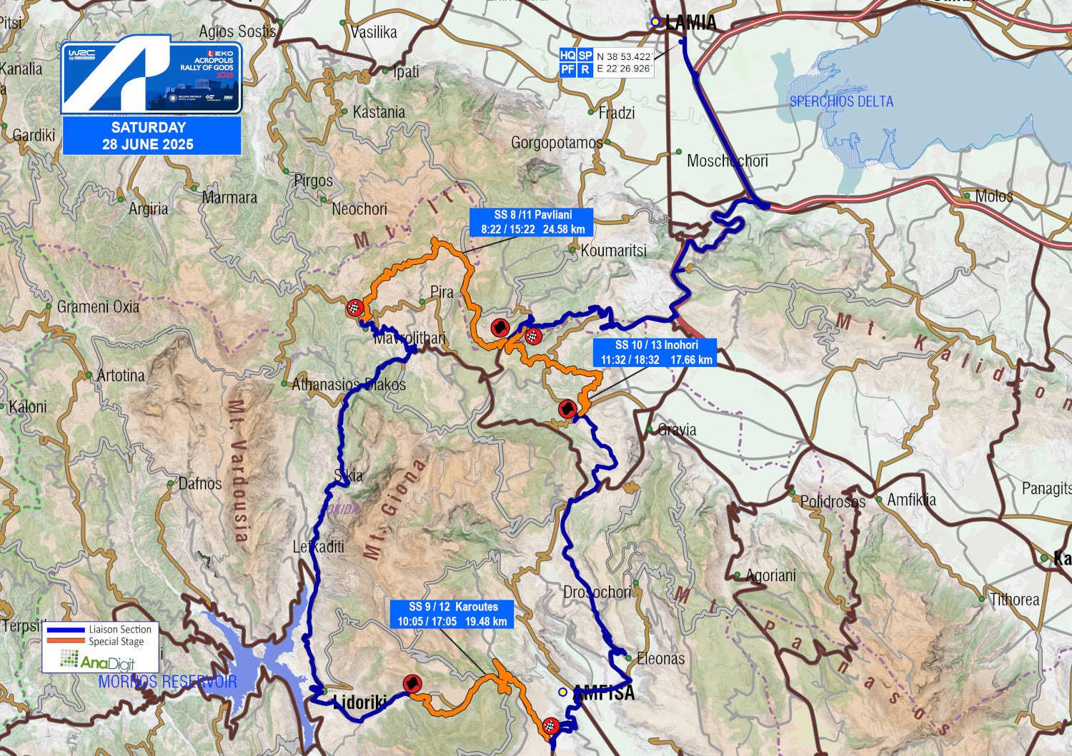
SATURDAY 28 JUNE 2025
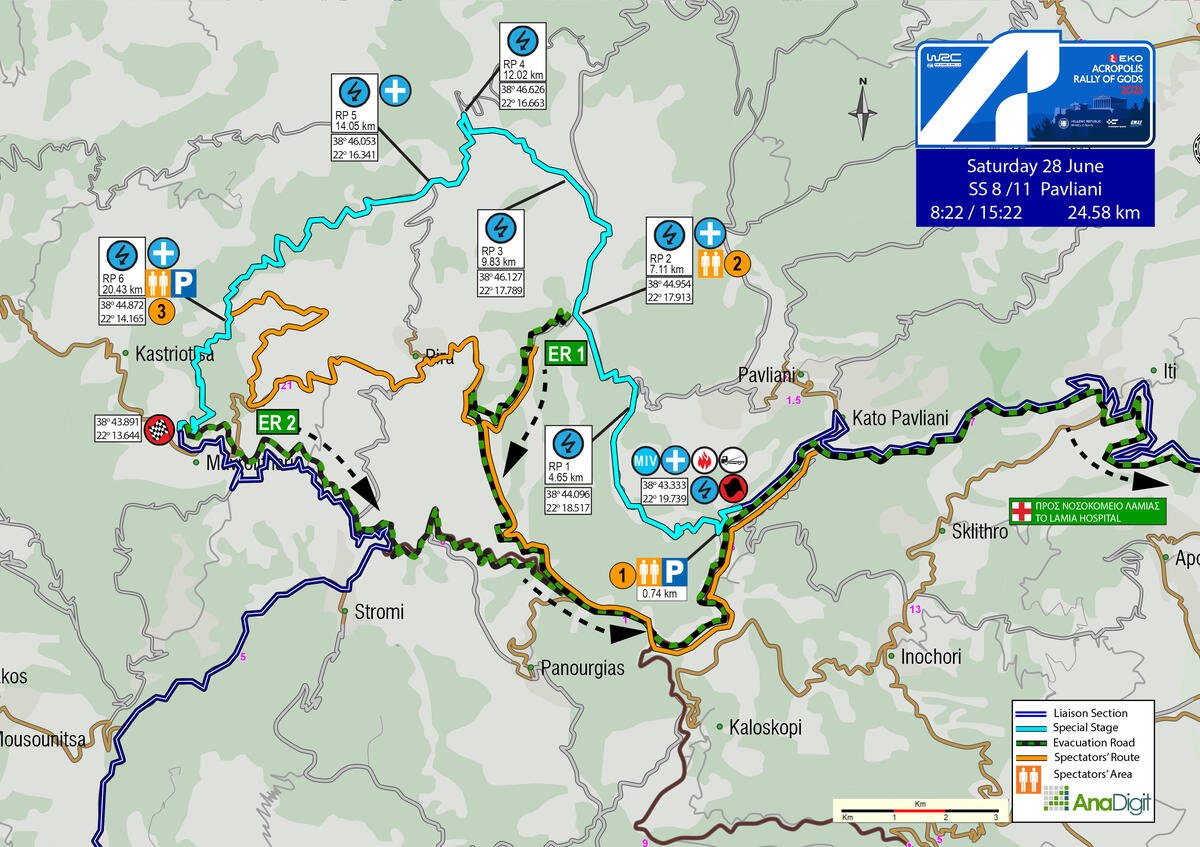
SS 8 - 11 PAVLIANI
Length: 24.58 km
Timetable
Road closing time: 05:22
First car due: SS 8 08:22
SS 11 15:22
NO TAPE, NO PUBLIC
Under the FIA safety regulations, areas without safety nets, fencing, or tape are prohibited. Find your spot only in the designated areas marked with safety precautions or in elevated spots.
INFO: Select your viewing point at least 30 minutes prior to the start of the special stage. After this time, no movement will be permitted on the road, including the start and finish areas.
Access points are divided into three categories based on the difficulty of the road surface. The category letter is displayed in bold next to each access number.
The categories are:
• S = Soft = Passenger car
• M = Medium = SUV
• H = Hard = 4x4 or Enduro motorcycle
DESCRIPTION
This classic Acropolis special stage returns to the 2025 itinerary in its familiar direction. It begins with a relatively fast section of about 7 km on a fairly hard surface, reaching the area of “Pyra of Heracles.” Approximately 2 km later, it enters the segment known as “Katavothra,” a popular spot for camping and watching a significant portion of the stage, renowned for its very high speeds. From there, the stage proceeds into the forest and transitions into the narrowest and most technical section of the entire rally, featuring continuous corners, before finishing just above the village of Mavrolithari.
Attention: Due to the road's narrowness, access -even on foot- from Mavrolithari toward the finish will be allowed until 1 hour and 30 minutes before the scheduled time of the first car. After that point, all traffic will be prohibited.
SPECTATOR ACCESS
1 (S)
Upon entering the village of Pavliani, you will see a playground on your left. At that spot, in front of the taverna, turn left. After 2.20 km, at a left-hand bend (caution: this is the Start of the special stage), continue on the tarmac. After another 1.20 km, turn back right onto an uphill gravel road. After 600 m, you will reach the 0.74 km of the special stage.
Attention: If you choose to watch the special stage from a spot near the start, you must park AFTER the intersection where the control is located.
Click to navigate
SS 8-11 PAVLIANI ACCESS 1 (0.74km)
2 (M)
Upon entering the village of Pavliani, you will see a playground on your left. At that spot, in front of the taverna, turn left. After 2.20 km, at a left-hand bend (caution: this is the Start of the special stage), continue on the tarmac. After 6.60 km, on your right you’ll see a café (“Katafygio Oitis”). After 150 m, turn right towards “Kastriotissa – Mavrolithari – Pyra”. After 4.80 km, turn back right onto an uphill gravel road, and after 3.90 km, you’ll reach the area of “Pyra of Heracles”, at the 7.11 km of the special stage.
Attention: Please park according to the marshals’ instructions. This road serves as an ambulance escape route in case of emergency. Do not block it. Blocking the emergency route may lead to the cancellation of the special stage.
Click to navigate
SS 8-11 PAVLIANI ACCESS 2 (7.11km)
3 (H)
Upon entering the village of Pavliani, you’ll see a playground on your left. At that point, in front of the taverna, turn left. After 2.20 km, at a left-hand bend (caution: this is the start of the special stage), continue on the tarmac. After 6.60 km, on your right, you’ll see a café (“Katafygio Oitis”). After 150 m, turn right towards “Kastriotissa – Mavrolithari – Pyra”. After 7 km, you reach the village of Pyra, and 4.20 km after the last house on your right, at a right-hand bend with two wooden poles on the left, turn right onto an uphill gravel road. After 4.55 km, you’ll arrive at the 20.43 km of the special stage.
Click to navigate
SS 8-11 PAVLIANI ACCESS 3 (20.43km)
SATURDAY 28 JUNE 2025
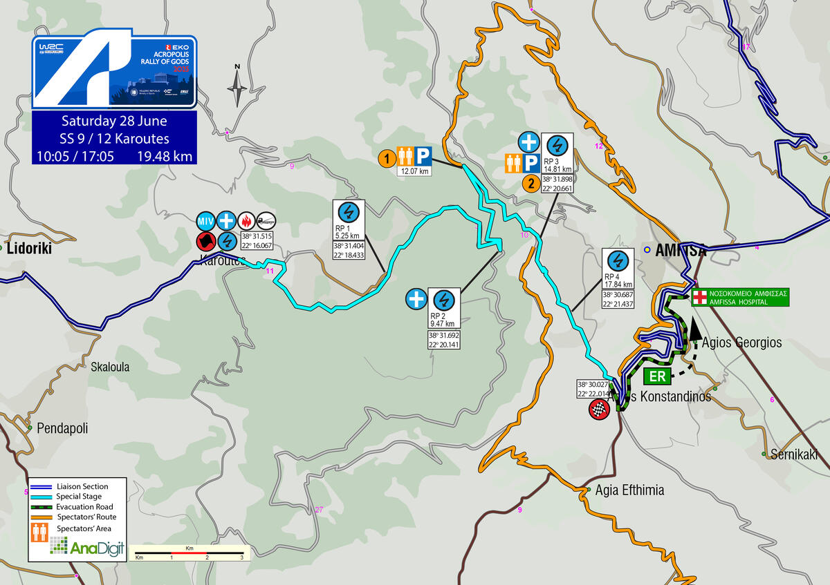
SS 9 – 12 KAROUTES
Length: 19.48 km
Timetable
Road closing time: 07:05
First car due: SS 9 10:05
SS 12 17:05
NO TAPE, NO PUBLIC
Under the FIA safety regulations, areas without safety nets, fencing, or tape are prohibited. Find your spot only in the designated areas marked with safety precautions or in elevated spots.
INFO: Select your viewing point at least 30 minutes prior to the start of the special stage. After this time, no movement will be permitted on the road, including the start and finish areas.
Access points are divided into three categories based on the difficulty of the road surface. The category letter is displayed in bold next to each access number.
The categories are:
• S = Soft = Passenger car
• M = Medium = SUV
• H = Hard = 4x4 or Enduro motorcycle
DESCRIPTION
Another iconic Greek stage dates back to the 1970s and 1980s. In 2025, its length is 19.48 km, as it ends on the tarmac section leading into Amfissa.
The stage begins in the village of Karoutes (on tarmac) and, following the initial uphill segments, it enters the forest, traversing a highly technical section. After 4 km, it connects with the old Karoutes road and descends through one of the most scenic routes in the Championship.
SPECTATOR ACCESS
1 (S)
Heading toward the center of Amfissa, you will reach the Police Headquarters, where you turn right. Continue to a roundabout and take the second exit. After 620 m, turn slightly right onto the very narrow Ylethou Street. After 340 m, turn right, and after another 1.10 km, turn right again. Continue for 7.80 km uphill, then at the top, turn left onto a dirt road. After 5.76 km, you will arrive at the 12.07 km mark of the special stage.
Click to navigate
SS 9-12 KAROUTES ACCESS 1 (12.07km)
2 (S+M)
Leaving Itea, with the Shell gas station on your left, turn left. After 2.40 km (you’ll see many parked vehicles on the right), continue straight and reset your trip meter. After 1.68 km, at a long left-hand bend, turn right uphill. At 3.88 km, continue straight, and at 3.80 km, where there is a school on the right, turn left towards Lidoriki. After 100 m, at the STOP sign, turn left, and after 400 m, you’ll pass the exit sign for the village of Agia Efthymia. After another 100 m, bear right onto a concrete road, and after 1 km, turn right again onto another concrete road. After 2.20 km, the surface changes to gravel, and after 1 km, at a junction with a road to Agia Triada (on the left), continue straight. After 5.60 km, you’ll reach the 14.81 km of the special stage.
Click to navigate
SS 9-12 KAROUTES ACCESS 2 (14.81km)
SATURDAY 28 JUNE 2025
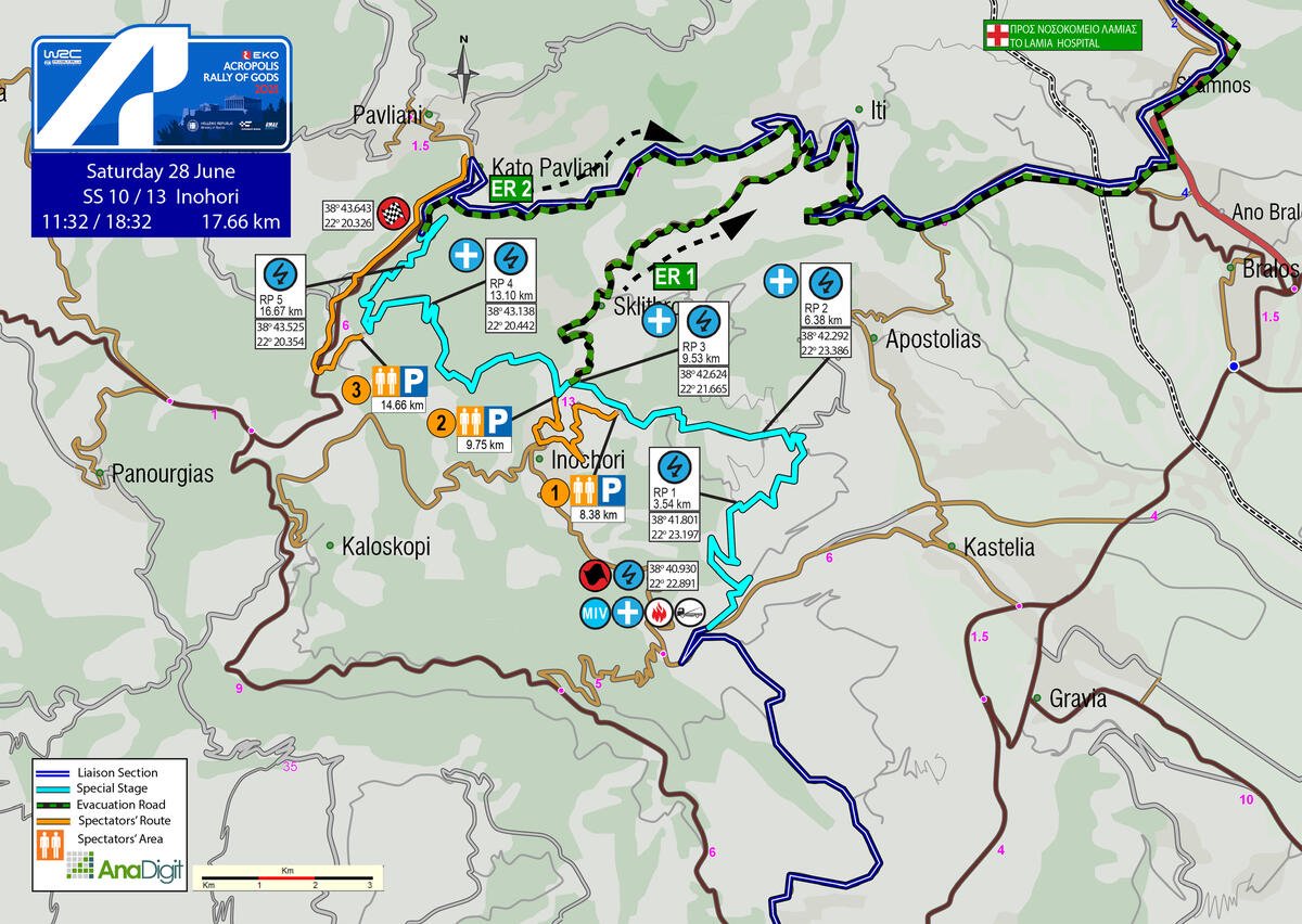
SS 10 - 13 INOHORI
Length: 17.66 km
Timetable
Road closing time: 08:32
First car due: SS 10 11:32
SS 13 18:32
NO TAPE, NO PUBLIC
Under the FIA safety regulations, areas without safety nets, fencing, or tape are prohibited. Find your spot only in the designated areas marked with safety precautions or in elevated spots.
INFO: Select your viewing point at least 30 minutes prior to the start of the special stage. After this time, no movement will be permitted on the road, including the start and finish areas.
Access points are divided into three categories based on the difficulty of the road surface. The category letter is displayed in bold next to each access number.
The categories are:
• S = Soft = Passenger car
• M = Medium = SUV
• H = Hard = 4x4 or Enduro motorcycle
DESCRIPTION
The first 3.54 kilometres are uphill, with an excellent surface. The next 2.83 kilometres are a spectator’s dream! The stage winds through quarry terrain, offering expansive viewing areas and ample space for safe camping. This is followed by 3.70 kilometres of a relatively narrow forest road, which briefly merges with the Skliro–Oinochori tarmac for 220 metres before returning to a narrow gravel road - a section with limited spectator interest - leading to the finish just outside the village of Kato Pavliani.
SPECTATOR ACCESS
1 (M–H)
Upon reaching the main square of Oinochori – whether arriving from Kastelia or Kaloskopi – turn right towards the church of Agia Aikaterini. Continue to the left, leaving the guesthouse “Ta Tessera Vouna” on your right-hand side. After 150 m, cross a small stream and enter a narrow gravel road. After 2.3 km, you will reach the 8.38 km of the special stage.
Click to navigate
SS 10-13 INOHORI ACCESS 1 (8.38km)
2 (S)
Access to the intermediate tarmac section of the special stage is ONLY available via Ιnohori. By following the link below, you will arrive at a point 700 m beyond the last house at the exit of Ιnohori. Please park as directed by the marshals and continue on foot, walking 500 m uphill on a tarmac road to reach the 9.75 km of the special stage, where the rally cars transition from tarmac to gravel.
Access from Sklithro to the 9.53 km of the special stage (where the cars transition from gravel to tarmac) will be on foot only, over a distance of approximately 1.5 km. Traffic will be stopped at the village's last house, as no parking spaces are available and the road is narrow. If you choose this access, make sure to park inside the village in a way that does not block the possible passage of an ambulance in case of emergency.
Click to navigate
SS 10-13 INOHORI ACCESS 2 (9.75km)
3 (Μ)
Entering the village of Nea Pavliani, you’ll reach a junction where the road straight ahead leads to Ano Pavliani, and left to Kaloskopi. At this point, where you’ll see a basketball court and a taverna, reset your trip meter and turn left. After 3.6 km, at a fork with a yellow sign and a chapel in the distance, turn left. After 300 m, at another fork, turn left again (the right road leads to Agia Triada) and after 600 m, you will reach the 14.66 km of the special stage.
Attention: This road serves as an ambulance emergency exit. It must remain clear at all times.
Blocking the escape route may result in the cancellation of the special stage.
Click to navigate
SS 10-13 INOHORI ACCESS 3 (14.66km)
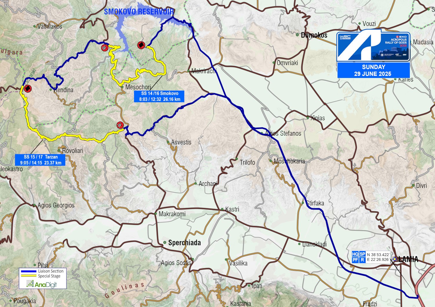
SUNDAY 29 JUNE 2025
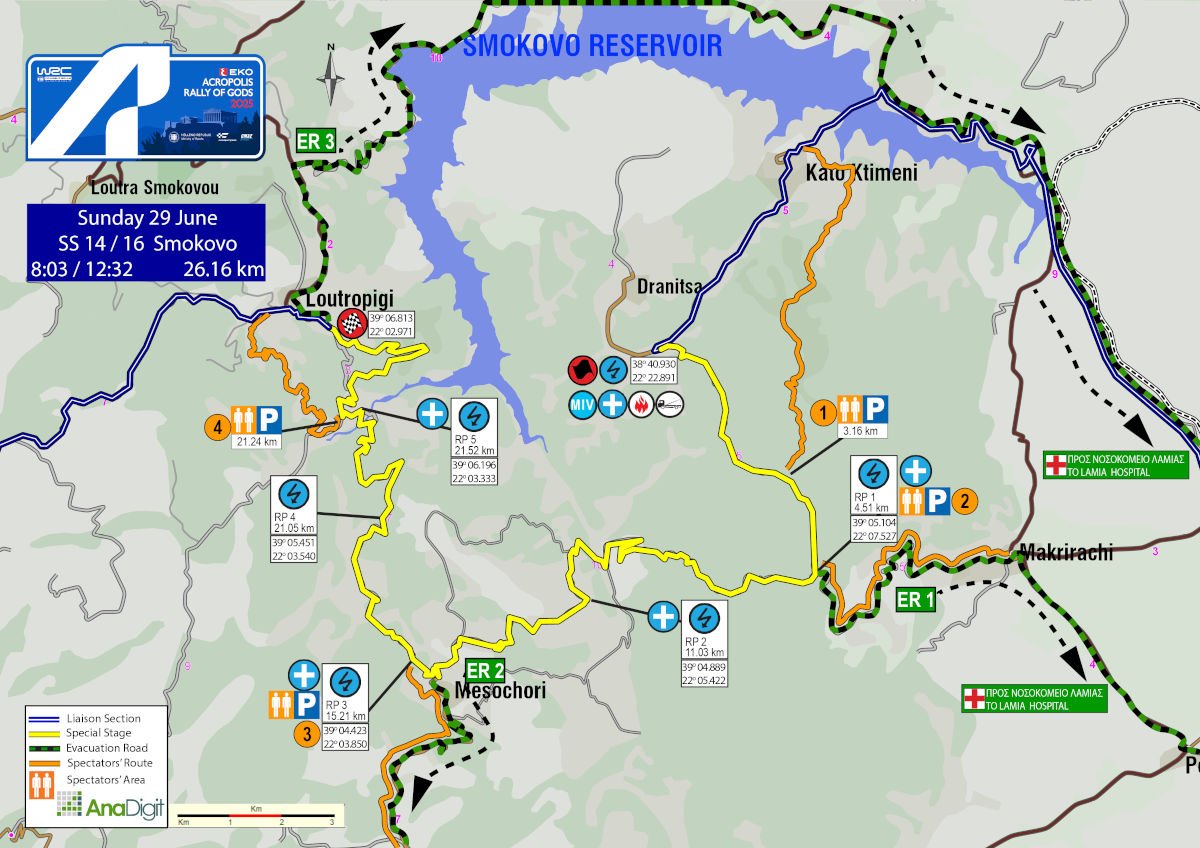
SS 14 - 16 SMOKOVO
Length: 26.16 km
Timetable
Road closing time: 05:03
First car due: SS 14 08:03
SS 16 12:32
NO TAPE, NO PUBLIC
Under the FIA safety regulations, areas without safety nets, fencing, or tape are prohibited. Find your spot only in the designated areas marked with safety precautions or in elevated spots.
INFO: Select your viewing point at least 30 minutes prior to the start of the special stage. After this time, no movement will be permitted on the road, including the start and finish areas.
Access points are divided into three categories based on the difficulty of the road surface. The category letter is displayed in bold next to each access number.
The categories are:
• S = Soft = Passenger car
• M = Medium = SUV
• H = Hard = 4x4 or Enduro motorcycle
DESCRIPTION
The rally returns to Thessaly after thirty years, introducing a brand new and highly technical special stage through the mountains surrounding the artificial lake that lends its name to the stage. It stands as the second longest stage of the 2025 edition, showcasing a varied surface.
Its standout features include considerable elevation changes and two water crossings anticipated to be highlight viewing spots!
SPECTATOR ACCESS
1 (M)
Driving on the Leianokladi–Karditsa provincial road or coming from Ktimeni, turn towards Ktimeni. After 1 km, where you’ll see an old truck bed on your left, turn left onto a downhill gravel road. After 750 m, at a split, turn right uphill. After 3.7 km, take the left road, and after 190 m, turn right. After another 1.2 km, you will reach the special stage at the 3.16 km.
Click to navigate
SS 14 - 16 SMOKOVO ACCESS 1 (3.16km)
2 (S)
Arrive at the main square of the village of Makryrrachi and reset your trip meter. After leaving the square, in 50 m, at a junction marked with a sign saying “Loutra Kaitsis – Karditsa”, continue straight ahead (if you are coming from Loutra Kaitsis, turn right at the sign for “Domokos – Lamia”). After 140 m, at a fork near a brown gate, proceed straight. Another 210 m later, at the next fork, turn right and head uphill. You will drive through Makryrrachi, and after 1 km, you will reach a navigable gravel road. After another 1 km, at a fork, keep left and go uphill. After 2.6 km, at another fork, turn right, where parking is strongly advised. After 800 m, you will arrive at the 4.51 km of the special stage.
Click to navigate
SS 14 - 16 SMOKOVO ACCESS 2 (4.51km)
3 (S-Μ)
From the football field in the village of Palaia Giannitsou, take the road on the left towards the village of Pappa. Zero your trip meter at the open area on the right side of the road, just after the last houses - look for a swing there. After 3.8 km, at a right-hand bend, turn left onto a drivable dirt road. After 700 meters, at a fork, take the left-hand track. Park 1 km later at a clearing, and after another 200 meters, you’ll reach the 15.21 km mark of the special stage.
Click to navigate
SS 14 - 16 SMOKOVO ACCESS 3 (15.21km)
4 (S)
You reach the exit of the village of Loutropigi (Smokovo) and head towards Rentina. Reset your trip meter at the sign marked “Loutropigi END. " After 90 m, turn diagonally left at the storage buildings. After 70 m, the surface changes to gravel, and 130 m later, turn left onto a narrow downhill gravel road. After another 130 m, at a fork, continue straight and downhill. At 1.17 km, ignore the road to your back left, and at 2.27 km, turn left at a junction. After 500 m, park your car. Following a designated path, you will arrive (after 670 m) at the 21.24 km of the special stage, at a water crossing.
Click to navigate
SS 14 - 16 SMOKOVO ACCESS 4 (21.24km)
SUNDAY 29 JUNE 2025
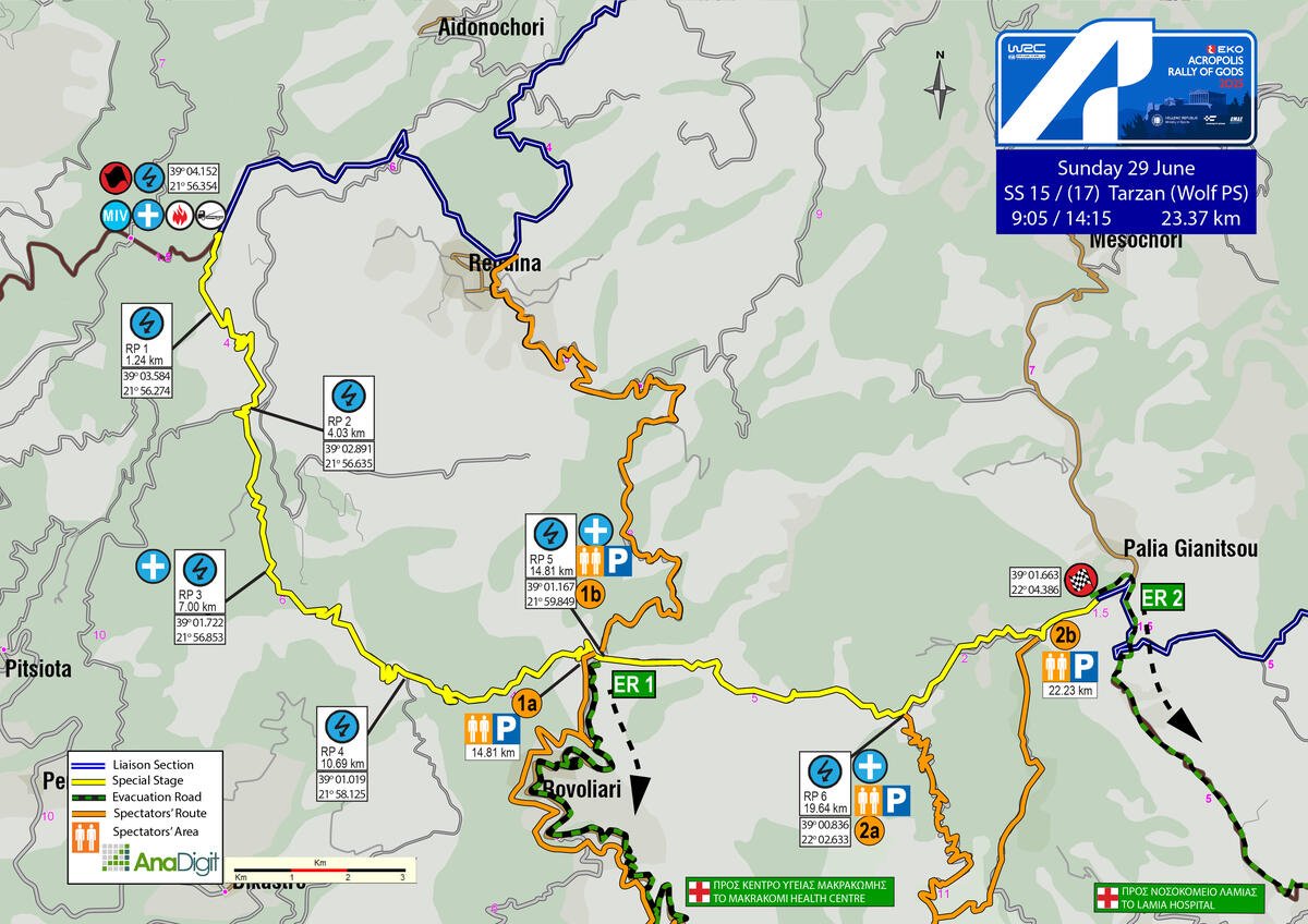
SS 15 - 17 TARZAN – WOLF POWER STAGE
Length: 23.37 km
Timetable
Road closing time: 06:05
First car due: SS 15 09:05
SS 17 14:15
NO TAPE, NO PUBLIC
Under the FIA safety regulations, areas without safety nets, fencing, or tape are prohibited. Find your spot only in the designated areas marked with safety precautions or in elevated spots.
INFO: Select your viewing point at least 30 minutes prior to the start of the special stage. After this time, no movement will be permitted on the road, including the start and finish areas.
Access points are divided into three categories based on the difficulty of the road surface. The category letter is displayed in bold next to each access number.
The categories are:
• S = Soft = Passenger car
• M = Medium = SUV
• H = Hard = 4x4 or Enduro motorcycle
DESCRIPTION
The first ten kilometres or so of the stage flow through a dense forest on a section with a hard and consistent surface, enabling crews to establish their rhythm early on. The next four kilometres present a wider, smoother road.
However, after the junction towards Rovoliari and Rentina, the infamous Tarzan cobblestones begin - a legendary stretch that pushes both cars and crews to their limits. With its rocky terrain and steep gradients, this section demands maximum concentration and tests the endurance of both suspension setups and tyres. It is a road that has truly earned its place in the rally’s heritage.
The special stage ends just before the entrance to the village of Palaia Giannitsou.
SPECTATOR ACCESS
1a (M)
Driving along the Lamia-Karpenisi provincial road, at Vitoli turn right onto an uphill concrete road, signposted “Rovoliari”. You’ll reach the village, and after exiting it, continue for approximately 2 km on a moderate-quality gravel road, until you arrive 400 metres before the 14.81 km of the special stage.
Please adhere to the organisers’ instructions and park your vehicle in the designated areas.
Attention: This road serves as an ambulance emergency exit. It must remain clear at all times.
Blocking the escape route may result in the cancellation of the special stage.
Click to navigate
SS 15-17 TARZAN ACCESS 1a (14.81km from Vitoli to Rovoliari)
1b (S)
Coming from Loutropigi (Smokovo) toward Rentína, you will reach an intersection at the entrance of the village. On your left is the refueling point for the rally cars. Follow the road to the left (you’ll see a plane and a sign toward “Moni Rentinas”. After 1.9 km, turn left at the intersection. After 6.40 km, you will pass “Moni Rentinas” on your right. In 2 km, the surface becomes gravel. After another 3.3 km, you will reach the 14.81 km of the special stage.
Click to navigate
SS 15-17 TARZAN ACCESS 1b (14.81km from Rentina)
2 (Μ)
Heading from Lamia towards Makrakomi, at the traffic light junction turn right towards Makrakomi. After 650 meters, turn left, and after another 600 meters, go straight through the roundabout. In 100 meters, at the STOP sign, turn right. 800 meters later, turn right towards Tsouka, which you’ll reach after 6.38 km. After 450 meters, turn hard left, and 80 meters later, hard right. In 680 meters, you’ll see the village cemetery on your left, and after another 140 meters, the road turns to gravel.
2_a (M)
After 850 m, at a three-way junction, take the right-hand road. Continue for 3.90 km, where you'll see a small house on the right, then turn right. After 5.78 km, you’ll arrive at the 19.64 km of the special stage.
Click to navigate
SS 15-17 TARZAN ACCESS 2a (19.64km)
2_b (M)
Follow the link above to reach the beginning of the gravel road, and from there, to reach the 22.33 km of the special stage, continue by following the 2_b instructions without using navigation.
After 4.25 km, turn right onto the “white” concrete road. After 960 m, turn back right, and after another 180 m, on a right-hand bend, turn left. After 4.77 km, you will reach the 22.33 km of the special stage.
Wolf Power Stage Podium
While driving on the Lamia–Karpenisi provincial road, take the first exit for Makrakomi. After 3.2 km, at the intersection where the Health Center is on your left, turn right towards Giannitsou / Palaia Giannitsou / Pappa. Continue through the villages of Platystomo and Giannitsou, and by following the signs and markings for Palaia Giannitsou, you’ll reach the village’s football field, where you can park. From there, the finish line is accessible on foot in 300 meters.
Click to navigate
SS 17 TARZAN - POWER STAGE PODIUM