")
")

Download Google Earth Maps
* You must have the Google Earth app in order to view the above files
*download the map
THURSDAY 7 SEPTEMBER 2023
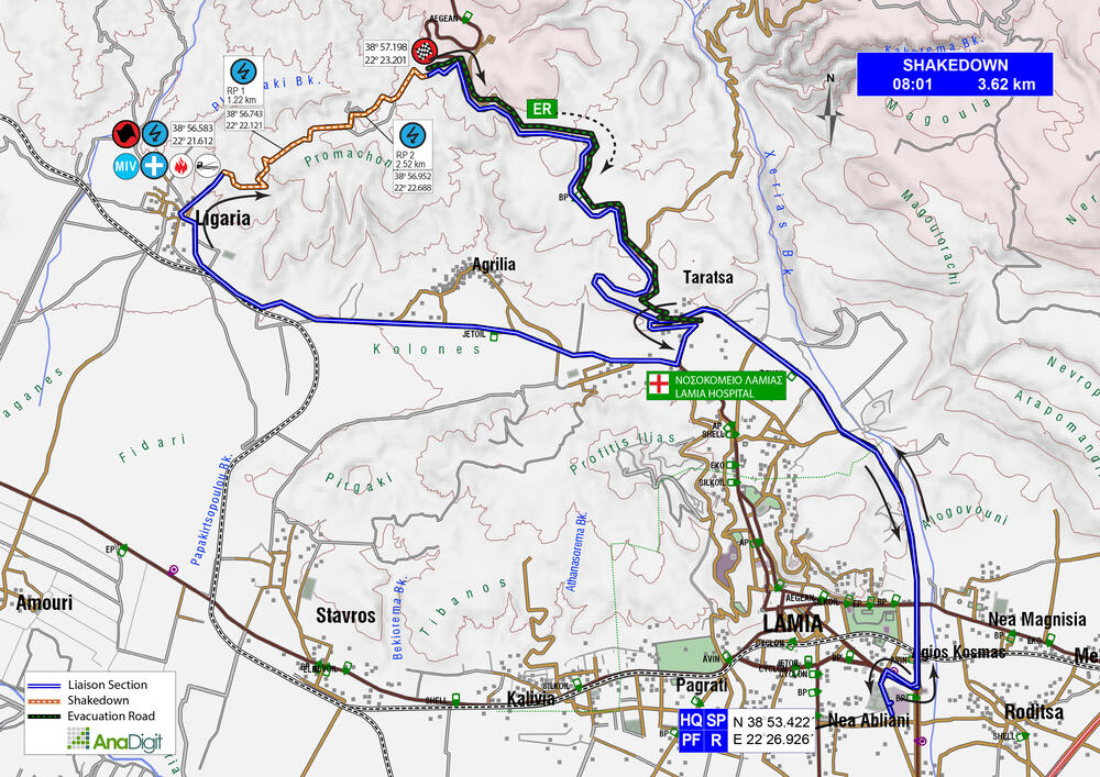
SHAKEDOWN
Length: 3.62 km
Road closing time: 04:56
First car due: 08:01
DESCRIPTION
A representative special stage, with the first part being fast, even on a hard surface. Then, as it goes uphill, the surface gets softer, also fast, while the road is significantly wider.
SPECTATOR ACCESS
As there is no intermediate access road for the Shakedown, spectators are advised to enter the stage on foot through the “Stop”, having previously parked their car on the main road “Lamia-Domokos”.
As there is no intermediate access for the Shakedown, entry (on foot only) from the “Stop” will be allowed until 07:00. Earlier, park on the “Lamia-Domokos” road, according to the instructions of the Police and the officials on duty.
Click to navigate
SHAKEDOWN STOP
INFO: Find your spot 30 minutes before the time of the first competitive car, as thereafter, you will be prohibited from walking or moving on the special stage, including the start and finish.
*download the map
FRIDAY 8 SEPTEMBER 2023
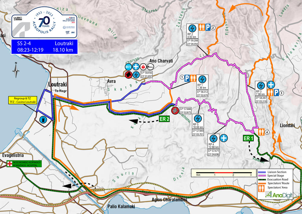
SS 2-4 LOUTRAKI
Length: 18.10 km
Timetable
Road closing time: SS 2 05:20
First car due: SS 2 08:23
SS 4 12:19
INFO
The road will remain closed between the first (SS2) and the second (SS4) passage.
DESCRIPTION
It is a quite technical special stage. The Start is located in the settlement “Nea Politia”, on the asphalt road. After about 1.40 km on a hard surface, it reaches the well-known crossroads of the “trees”, where it continues to the left, uphill. After 3 km, it reaches the junction towards “Prathi”, where it turns right, on an extremely wide and pleasant section of 3.60 km, until it “enters” the tarmac. After 2.8 very fast downhill tarmac kilometres, it re-enters the gravel for the last, very tight section to the finish, at the beginning of the tarmac that leads to “Kallithea Settlement”.
ENJOY THE RALLY!
On the following pages are the access roads that organisers have chosen for spectators. Next to the number of each access road, there is a letter indicating the difficulty of the road surface. These are:
- S= Soft= Passenger car (hatchback, sedan, etc.)
- M= Medium= SUV
- H= Hard= 4x4 or Enduro motorcycle
SPECTATOR ACCESS
1 (S)
On the main Loutraki avenue, where the PepsiCo-Ivi factory is on the right, turn right. After 3.00 km turn right, towards "Kallithea" settlement and after another 3.70 km continue slightly to the left, on the wide gravel road. In 700 meters you will reach the 1.36 km of the special stage.
NOTE: Make sure to park without blocking the tarmac road coming from Loutraki. It is a "liaison section" for rally cars and must remain clear. There is plenty of parking space on the wide gravel road.
Click to navigate
SS 2-4 LOUTRAKI ACCESS 1 (1.36km)
The initial driving directions are identical for access roads 2, 3 and 4.
Moving on the Athens-Corinth highway towards Corinth, exit right, to Aghii Theodoroi. In 360 m you will meet a toll station. After 170 m, at the “Stop” sign, turn left and after 1.73 km (just before train rails) turn left again on the very first road. In 580 m, having passed two roads on the right, turn slightly left and after 220 m (having passed under two bridges), turn left again. In 180 m turn right on a narrow uphill road to "Kiafa Beka". Then, you may select one of the following accesses:
2 (M)
After 2.77 km turn right onto the gravel road. In 1.43 km turn left. After 4.58 km you continue slightly right. After 5.80 km, where a tree in the middle of the road, continue straight ahead. After 5.62 km you will reach the 4.63 km of the special stage.
Click to navigate
SS 2-4 LOUTRAKI ACCESS 2 (4.63km)
3 (M)
After 2.77 km, turn right onto the gravel road. After 1.43 km, turn left. Continue for 4.58 km and turn left. After 1.03 km the surface becomes asphalt, and after another 1.0 km, you will reach the 7.98 km of the special stage, at the point where the rally cars turn from gravel to tarmac.
Click to navigate
SS 2-4 LOUTRAKI ACCESS 3 (7.98km)
4 (S)
After 2.77 km (where a gravel road on the right), you continue straight ahead. After 1.46 km, the Police will stop traffic. In walking distance (500 m) you will reach the 10.79 km of the special stage, where it goes from tarmac to gravel.
Please note: The road will be blocked by the Police 500m before the 10.79 km of the ss, as it is an evacuation route in case of an emergency. Please keep the road free.
Blocking an evacuation route may cause the special stage to be cancelled.
Click to navigate
SS 2-4 LOUTRAKI ACCESS 4 (10.79km)
*download the map
FRIDAY 8 SEPTEMBER 2023
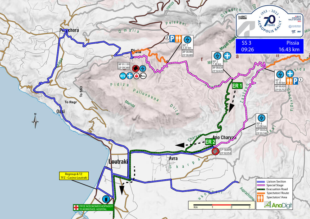
SS 3 PISSIA
Length: 16.43 km
Timetable
Road closing time: 06:23
First car due: 09:26
DESCRIPTION
The stage starts from the exit of the village of Pissia, towards the “Faneromeni” church. The first 3.35 km are narrow and rather twisty uphill until the “Faneromeni” church. At this point and for the next 8 km it goes relatively fast downhill, up to the riverbed where it turns right. Another 6 km follow driving next to or crossing the riverbed, up to the finish line.
Please note:
1) From the village square (where there is a church) and up until the Start of the stage (about 700m), the road section will be closed to traffic as it is incredibly narrow.
2) Access from the Start of the special stage “Harvati” of 2022 will be blocked by the Police as it is an ambulance evacuation road.
ENJOY THE RALLY!
On the following pages are the access roads that organisers have chosen for spectators. Next to the number of each access road, there is a letter indicating the difficulty of the road surface. These are:
- S= Soft= Passenger car (hatchback, sedan, etc.)
- M= Medium= SUV
- H= Hard= 4x4 or Enduro motorcycle
SPECTATOR ACCESS
1 (M-H)
Starting from the square of “Pissia” (where there is a church), exit the village towards “Shinos” and after 0.9 km turn right on the narrow uphill road. After 2.1 km you reach the 3.20 km of the stage, at “Faneromeni” church.
Click to navigate
SS 3 PISSIA ACCESS 1 (3.20km)
2 (Μ)
Moving on the Athens-Corinth motorway in the direction of Corinth, take the exit to Ag. Theodoroi. In 360 m, you meet a toll station. After 170 m, at the “Stop”, turn left and after 1.73 km (just before the train rails), turn left again. In 580 m, having "left" two roads on the right, turn slightly left, and after 220 m (having passed under two bridges), turn left again. In 180 m, turn right on a narrow uphill road to "Kiafa Beka".
After 2.77 km, turn right onto the gravel road and in 1.43 km turn left. After 4.58 km, continue slightly right. In 5.80 km (where a tree is in the middle of the road), turn right backwards and downhill and in 240 m follow the road to the left. After 200 m turn right and after 2.60 km (where you meet a road on the right) continue left. In 250 m you will have reached the 10.49 km of the special stage.
Click to navigate
SS 3 PISSIA ACCESS 2 (10.49km)
FRIDAY 8 SEPTEMBER 2023
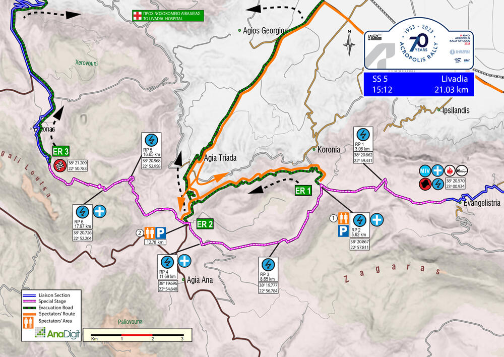
SS 5 LIVADIA
Length: 21.03 km
Road closing time: 12:09
First car due: 15:12
DESCRIPTION
The first 5.6 km were previously used as part of the "Evangelistria" special stage. This section has a very good surface. However, as it has been paved along the way, it now turns left and passes through two old marble quarries before crossing the asphalt road of the "Aghia Anna" village. Following this point, there is a 4.2 km section that is wide and fast, and then it narrows into a forested road. After another 4.2 km, the stage ends nearly 1.7 km before the village of “Elikonαs”.
ENJOY THE RALLY!
On the following pages are the access roads that organisers have chosen for spectators. Next to the number of each access road, there is a letter indicating the difficulty of the road surface. These are:
- S= Soft= Passenger car (hatchback, sedan, etc.)
- M= Medium= SUV
- H= Hard= 4x4 or Enduro motorcycle
SPECTATOR ACCESS
1 (S)
Take the “Thiva-Livadia” road and then turn left towards “Agia Triada”, “Agia Anna” and “Domvraina”. Drive for 2.0 km and then make a left turn. After driving for 5.77 km, you will arrive at “Agia Triada” village. Continue through the village and reset your odometer at the exit. After driving for 1.84 km, you will see a faded road sign and should turn left onto the tarmac road. Drive for another 4.94 km (look for plane trees) and then turn right onto a gravel road. After 1.38 km, you will have reached the 5.62 km of the stage.
Note: Park according to the marshals’ instructions. This is an evacuation route. Blocking it may cause the special route to be cancelled.
Click to navigate
SS 5 LIVADIA ACCESS 1 (5.62km)
2 (S)
To reach the 12.78 km point of the special stage, take a left turn on the "Thiva-Livadia" road towards "Agia Triada", "Agia Anna", and "Domvraina". After 2.0 km, take another left turn and continue for 5.77 km until you reach the "Agia Triada" village. Once you've crossed the village, reset your odometer and drive for another 2.85 km. You'll reach the point where the route crosses the asphalt and continues towards the village of "Elikonas”.
Note: The traffic will be stopped by the Police 500 m before the 12,78 km of the ss (from Agia Triada village) as it is an evacuation route. Blocking it may cause the cancellation of the special stage.
Click to navigate
SS 5 LIVADIA ACCESS 2 (12.78km)
FRIDAY 8 SEPTEMBER 2023
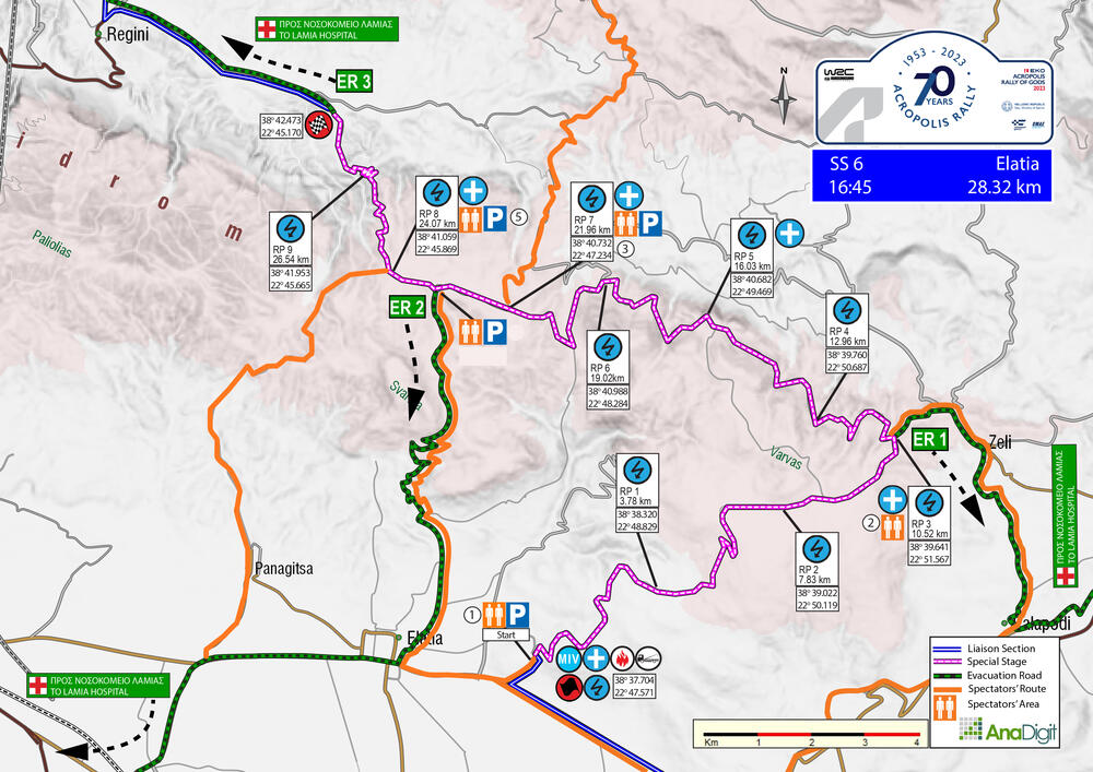
SS 6 ELATIA
Length: 28.32 km
Road closing time: 13:42
First car due: 16:45
DESCRIPTION
This year's stage is a new version of an old route, never used in the past. It begins with a 10.52 km uphill section, wide and fast, leading to Zeli village. After turning left, drivers will face an 11.44 km section of twisty, hard surface road. Another left turn will bring them (after 1.81 km) to the famous water splash of last year's Elatia stage. The final 4.63 km are downhill and include several hairpins leading to the finish.
ENJOY THE RALLY!
On the following pages are the access roads that organisers have chosen for spectators. Next to the number of each access road, there is a letter indicating the difficulty of the road surface. These are:
- S= Soft= Passenger car (hatchback, sedan, etc.)
- M= Medium= SUV
- H= Hard= 4x4 or Enduro motorcycle
SPECTATOR ACCESS
1 (S)
To get to the Start of SS6, drive from Livadia towards Lamia and pass through the villages of Thourio, Heronia, and Davlia. At the roundabout, take a right towards Atalanti. After approximately 7 km, you'll come across a junction where you should turn left towards Elatia. Keep going for 4.15 km until you see a church on your right. Park after the junction for the road, in the direction of Elatia village. After 750m. is the start of the special stage.
Click to navigate
SS 6 ELATIA ACCESS 1 (start)
2 (S)
Driving from Livadia towards Lamia, you will pass through the villages of Thourio, Heronia, and Davlia before arriving at a roundabout. At the roundabout, take a right turn towards Atalanti. Keep driving for about 7 km until you reach a junction (“Elatia” left and “Sfaka-Katalyma” right) where you should continue straight ahead. where you continue straight. After 5.10 km, you leave the main road towards “Kalapodi-Zeli”. When you enter Kalapodi village after 200 m, look out for the "Zeli left" sign and take a left turn. Continue driving for 3.70 km to reach Zeli village. Park your car in the wide space on the right side of the road and continue on foot uphill, as cars are not allowed to park since it is an evacuation road. After 700 meters, turn left and then again left after 20 m, towards "Προφήτη Ηλία". You will reach the 10.52 km of the stage after 1.10 km, where the road changes from tarmac to gravel.
Note: Park according to the marshals’ instructions. This is an ambulance evacuation route. Blocking it may cause the special stage to be cancelled.
Click to navigate
SS 6 ELATIA ACCESS 2 (10.52km)
3 (M)
Entering “Kamena Vourla” from the north, you will arrive at a roundabout where you continue straight. In 0.70 km where a kiosk on your right hand and the Supermarket “Γαλαξίας”, turn right. In 150 m, at the “T” junction (sign “Ι.Ναός Μεταμορφώσεως, Περιφερειακός Καρυά 10”) turn right and in another 150 m, having passed under a bridge, turn again right. In 300 m, where a sigh “Ιερά Μονή Μεταμόρφωσης- Καρυά 10”, turn left and start ascending the mountain. In 9.85 km, you'll reach a village square where you should take a right turn and exit through the second exit on your right. In 150 m, at the white house, make a right turn and then take a slight right after 200 m. After traveling 12.20 km, you'll come across a junction where you'll meet the 21.96 km of the stage.
Click to navigate
SS 6 ELATIA ACCESS 3 (21.96km)
4 (S)
Driving from Livadia towards Lamia, you'll come across villages “Thourio”, “Heronia”, and “Davlia”. When you reach a roundabout, take a right towards “Atalanti”. After about 7 km, there will be a junction where you should take a left towards “Elatia” and not right towards “Sfaka-Katalyma”. You'll then see cypress trees on your right and a sign «Ι.Ναός Αγ.Αποστόλων». Turn right and keep slightly left after 170 m. After another 130 m, turn right and continue for 2.46 km until the road turns into gravel. After 80 m, turn left, and in 5.10 km, you'll reach the 23.14 km of the stage. You can either stay at that spot or walk left for 730 km to arrive at the famous water splash.
Note: Park according to the marshals’ instructions. This is an ambulance evacuation route. Blocking it may cause the special stage to be cancelled.
Click to navigate
SS 6 ELATIA ACCESS 4 (23.14km)
5 (Η)
Heading from Modi to Elateia, turn left at the “Stop” sign. Continue on this road for 1.45 km until you reach the village of "Panagitsa". Drive through the village and stay on the main road, which will become gravel after 480 m. When you reach a roadside memorial, turn left. After 1.37 km, you will come to a fork in the road. Turn right, and then turn right again in 640 m, passing a secondary gravel road on your right. At the "T" intersection 1.18 km later, turn right. Continue for 3.35 km until you reach the 24.07 km of the stage, which is 290 m past the water splash.
Click to navigate
SS 6 ELATIA ACCESS 5 (24.07km)
*download the map
SATURDAY 9 SEPTEMBER 2023
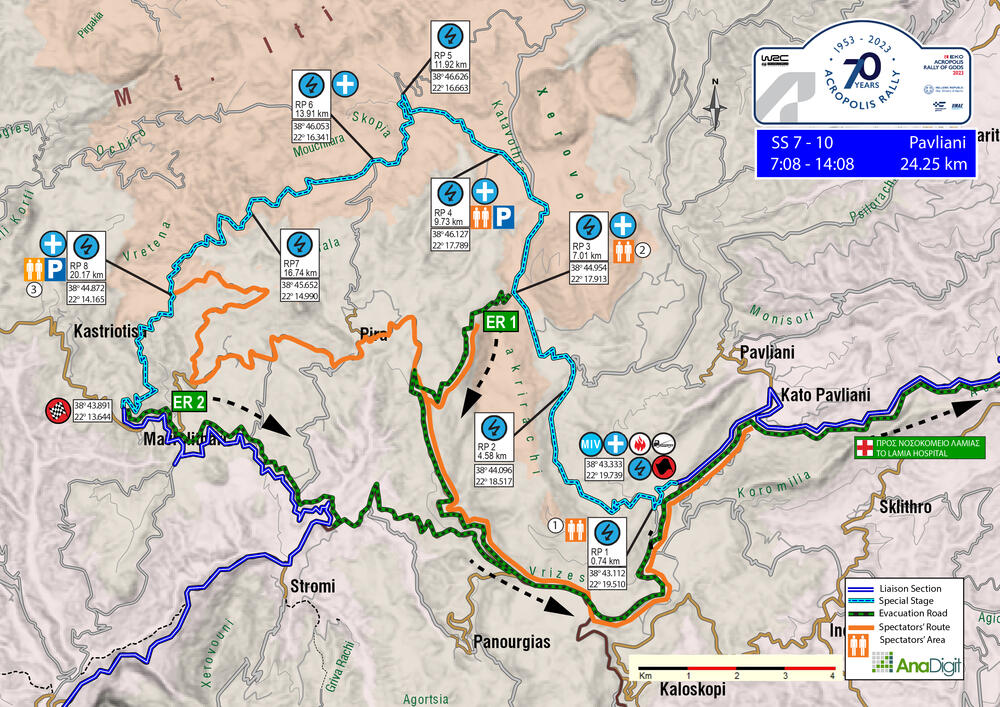
SS 7/10 PAVLIANI
Length: 24.25 km
Road closing time: SS 7 04:05
SS 10 11:05
First car due: SS 7 07:08
SS 10 14:08
DESCRIPTION
A classic Acropolis special stage, which everyone missed last year, as it was not included in the itinerary. The stage begins with a fast 7 km section on a hard surface, leading to the "Pyre of Heracles" area and to “Katavothra” plateau, which is perfect for camping and viewing a long, fast section. The route then enters a forest and follows a narrow, winding path, eventually finishing just above Mavrolithari village. To ensure safety, the road will be closed to traffic from the village of Mavrolithari to the finish due to its narrowness.
Note: The special stage will be repeated twice. The conditions will be carefully considered, and the Organization may suggest that marshals allow spectators to move in the rally route’s direction for a limited time.
ENJOY THE RALLY!
On the following pages are the access roads that organisers have chosen for spectators. Next to the number of each access road, there is a letter indicating the difficulty of the road surface. These are:
- S= Soft= Passenger car (hatchback, sedan, etc.)
- M= Medium= SUV
- H= Hard= 4x4 or Enduro motorcycle
SPECTATOR ACCESS
1 (S)
As you enter Pavliani village, you'll see a playground on your left. Turn left in front of the tavern and continue for 2.20 km, where you’ll come across the start of the stage on your left. Continue on the tarmac road. After 1.20 km, take a right turn onto the uphill dirt road. After 600 meters, you will reach the 0.74 km of the stage.
Click to navigate
SS 7-10 PAVLIANI ACCESS 1 (0.74km)
2 (M)
Entering the village of Pavliani, there is a playground on the left. At that point, in front of the tavern, turn left. After 2.20 km, you will come across a left turn which is the Start of the stage. Continue on the tarmac road for 6.60 km, until you’ll see on your right a coffee shop called «Καταφύγιο Οίτης». Take a right turn towards "Καστριώτισσα-Μαυρολιθάρι-Πυρά" after 150 m and drive for 4.80 km. Take a sharp right-uphill hairpin onto the gravel road and drive for another 3.90 km until you reach the 7.01 km of the stage at the “Pyre of Heracles”.
Note: Park according to the marshals’ instructions. This is an ambulance evacuation route. Blocking it may cause the special stage to be cancelled.
Click to navigate
SS 7-10 PAVLIANI ACCESS 2 (7.01km)
3 (H)
Entering the village of Pavliani, there is a playground on the left. At that point, in front of the tavern, turn left. After 2.20 km, you will come across a left turn which is the Start of the stage. Continue on the tarmac road for 6.60 km, until you’ll see on your right a coffee shop called “Καταφύγιο Οίτης”. Take a right turn towards “Καστριώτισσα-Μαυρολιθάρι-Πυρά” after 150 m. To reach the village of “Pyre”, drive for 7 km. Then, after passing the last house on your right at the village's exit, turn right at the corner where you see two wooden poles on your left. This will lead you to an uphill gravel road. Drive for 4.55 km on this road, and you will reach the 20.17 km of the stage.
Click to navigate
SS 7-10 PAVLIANI ACCESS 3 (20.17km)
*download the map
SATURDAY 9 SEPTEMBER 2023
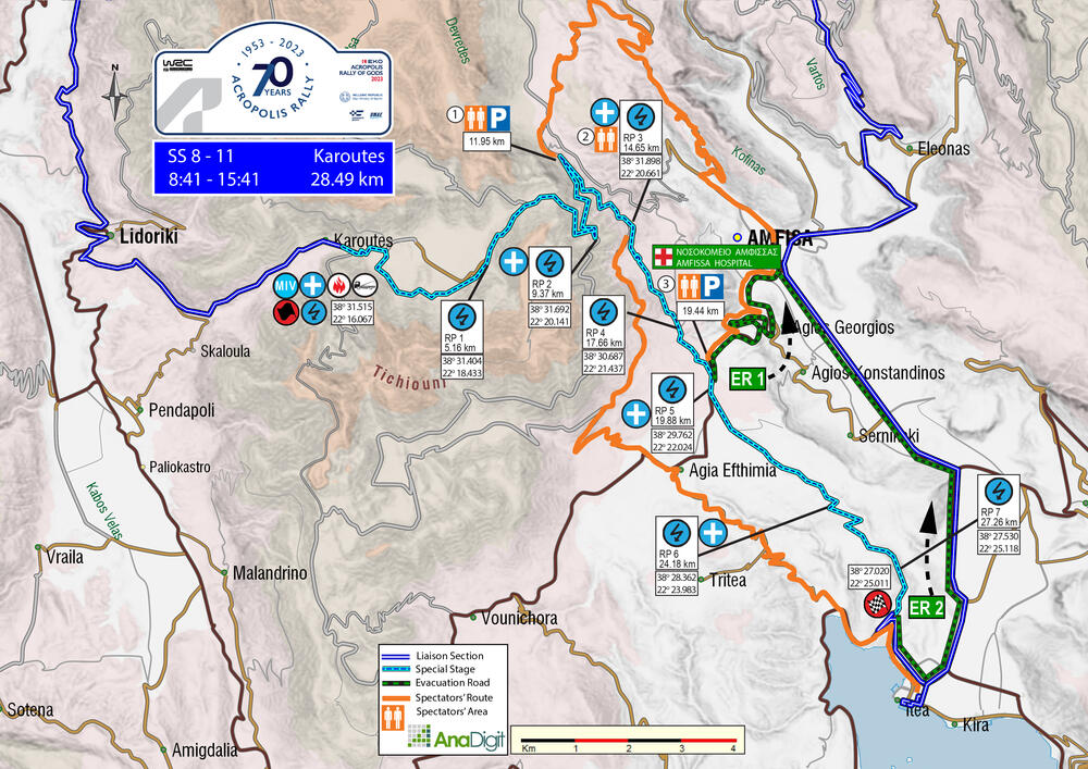
SS 8/11 KAROUTES
Length: 28.49 km
Road closing time: SS 8 05:38
SS 11 12:38
First car due: SS 8 08:41
SS 11 15:41
DESCRIPTION
An iconic Greek special stage from the '70s and '80s is making a comeback in the 2023 EKO Acropolis Rally after many years. This special stage is the longest in the event, spanning 28.36 km. It starts through the village of Karoutes (on asphalt), and after the first uphill sections, it enters the forest for a very technical part. After 4 km, it merges with the old road of Karoutes and descends to one of the most beautiful routes of the Championship. It reaches the tarmac of Amfissa (towards Ag. Efthymia), which it crosses, to finish after 9 km at Bauxites, just above the sea.
Note: The special stage will be repeated twice. The conditions will be carefully considered, and the Organization may suggest that marshals allow spectators to move in the rally route’s direction for a limited time.
ENJOY THE RALLY!
On the following pages are the access roads that organisers have chosen for spectators. Next to the number of each access road, there is a letter indicating the difficulty of the road surface. These are:
- S= Soft= Passenger car (hatchback, sedan, etc.)
- M= Medium= SUV
- H= Hard= 4x4 or Enduro motorcycle
SPECTATOR ACCESS
1 (S)
Passing in front of the fire brigade building in Amfissa, you reach a roundabout where you have to turn right and immediately left. After 620 m, take a diagonal left onto the narrow street called "Υλέθου". After 340 m, turn right and then turn right again downhill after 1.10 km. Continue for 7.80 km and turn left onto the gravel road at the summit. From there, it's 5.76 km until you reach the 11.95 km of the special stage.
Click to navigate
SS 8-11 KAROUTES ACCESS 1 (11.95km)
2 (S+M)
Coming out of Itea, with a "Shell" petrol station on your left, turn left. In 2.40 km (you will see many vehicles on the right) continue straight. After driving 1.68 km, take a right on a long left-hand bend and start ascending. Keep going straight ahead after reaching 3.88 km, then turn left towards Lidoriki when you see a school on the right after driving 3.80 km. Once you reach the "Stop" sign after 100 m, turn left, and after 400 m, you'll see a sign indicating the exit of the village Ag. Efthymia. Take a diagonal right turn on the concrete road after 100 m, and after 1 km, turn right on another concrete road. The surface will turn into gravel after 2.20 km, and after 1 km, where there is a junction to Ag. Triada on the left, keep going straight. You'll reach the 14.65 km of the special stage after driving 5.60 km.
Click to navigate
SS 8-11 KAROUTES ACCESS 2 (14.65km)
3 (S)
At the entrance of Amfissa, at the roundabout, exit towards "Hospital". Drive for about 6 km until you reach the 19.44 km of the stage, where the cars will transition from gravel to tarmac for a 300 m stretch before returning to dirt for the final section that leads to Bauxites.
Note: Park according to the marshals’ instructions. This is an ambulance evacuation route. Blocking it may cause the special stage to be cancelled.
Click to navigate
SS 8-11 KAROUTES ACCESS 3 (19.44km)
*download the map
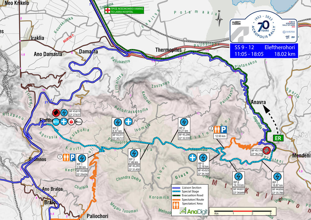
SATURDAY 9 SEPTEMBER
SS9/12 ELEFTHEROHORI
Length 18.02 km
Road closing time SS 9 07:59
Road closing time SS 12 14:59
First car due SS 9 11.05
First car due SS 12 18.05
Description
A well-known Greek special stage which will be run twice. Starting outside Eleftherohori village, it ascends relatively quickly to the first lake (which is empty). Then it enters the forest, in a very narrow part up to the junction of Drimaea. Afterwards, the route is very fast until the height of the second lake (no water). After about 1.5 km and up to the finish line, it is very narrow downhill.
Note: The special stage will be repeated twice. The conditions will be carefully considered, and the Organization may suggest that marshals allow spectators to move in the rally route’s direction for a limited time.
ENJOY THE RALLY!
On the following pages are the access roads organisers have chosen for spectators. Next to the number of each access road, there is a letter indicating the difficulty of the road surface. These are:
- S= Soft= Passenger car (hatchback, sedan, etc.)
- M= Medium= SUV
- H= Hard= 4x4 or Enduro motorcycle
SPECTATOR ACCESS
1 (M-H)
Heading from Lamia towards Athens, on the National Road, take the Amfissa-Bralos exit, where there is a toll station. After 160 m. turn right towards Patra-Delphi-Amfissa. In 12.50 km, at the junction that to the left leads to Eleftherohori, keep on the main road. After 2.63 km, keep straight at the junction leading towards Skamno-Oiti-Pavliani (right). Stay on the main road for 5.60 km and turn left towards Livadia. After 2.90 km, turn left towards Paleohori. In 800 meters at the junction, turn right, and in 200 meters, turn right again. In 400 m, the surface becomes gravel in front of the cemetery. At 600 m., at the junction, turn left. In 1.80 km turn right (uphill road), and in 6.0 km, you will have reached the 3.90 km of the special stage (at the lake).
INFO
Park according to the marshals’ instructions; they will accommodate as many vehicles as possible.
Click to navigate
SS 9-12 ELEFTHEROHORI ACCESS 1 (3.90km)
2 (M)
Starting from Thermopylae, head towards Anavra. Cross the village and reset the odometer in front of the last house at the village’s exit (on the right, with a playground). After 3.45 km (left turn - blue roadside memorial), turn right onto the uphill gravel road. After 3.20 km turn left and in 1.17 km you will have reached the 12.99 km of the special stage.
Click to navigate
SS 9-12 ELEFTHEROHORI ACCESS 2 (12.99km)
*download the map
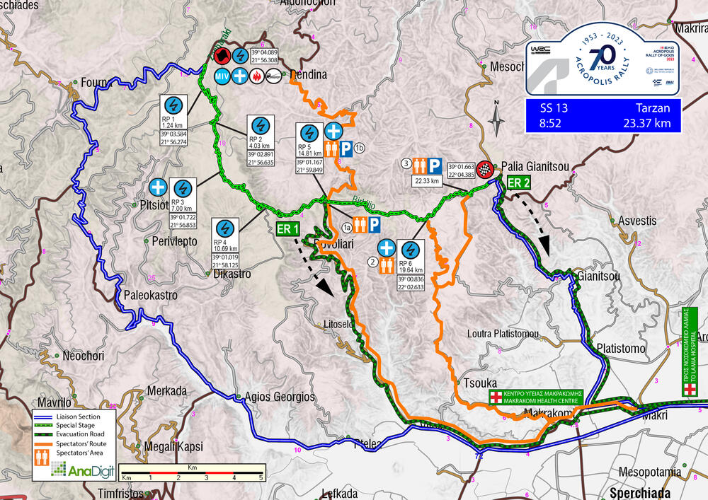
SUNDAY 10 SEPTEMBER
SS13 TARZAN
Length: 23.37 km
Timetable
Road closing time: SS 13 05.49
First car due SS 13 08.52
Description
Fans were thrilled to see "Tarzan" back in the rally in 2021. The initial 10 kilometres of downhill terrain take place on a tough forest road, followed by about 4 kilometres of smoother gravel. Once the route reaches the intersection of Rovoliari and Rentina villages, the famous cobblestone path of Tarzan begins, which can challenge both dampers and tyres. The special stage finishes just before entering the village of "Palaia Giannitsou."
ENJOY THE RALLY!
On the following pages are the access roads that organisers have chosen for spectators. Next to the number of each access road, there is a letter indicating the difficulty of the road surface. These are:
- S= Soft= Passenger car (hatchback, sedan, etc.)
- M= Medium= SUV
- H= Hard= 4x4 or Enduro motorcycle
SPECTATOR ACCESS
1a (M)
Starting from Rovoliari village, you will arrive 400 m from the 14.81 km of the special stage.
Note: Park according to the marshals’ instructions. This is an ambulance evacuation route. Blocking it may cause the special stage to be cancelled.
Click to navigate
SS 13 TARZAN ACCESS 1a (14.81km Rentina)
1b (S)
To get to the 14.81 km special stage, starting from the village of Smokovo head towards the village of Rentina. At the entrance of Rentina there is a plane. Cross the village. After travelling for 1.64 km, you will come to a square where you will see a coffee shop on your right. Turn left here. Continue on this road for 480 m until you see a "Stop" sign at a fork. Take the road to the right. After travelling for 6.40 km, you will come to another fork with a sign for "Μονή Ρεντίνας" on the right. Take the left road. After 1.90 km, you will see a sign for "Δήμος Σοφάδων Όρια Ρεντίνας". Continue straight. After 2.91 km, police officers will block traffic. Follow their instructions and park your vehicle accordingly. From there, it's just a 440 m walk to the 14.81 km of the special stage.
Click to navigate
SS 13 TARZAN ACCESS 1b (14.81km Rovoliari)
2 (Μ)
To reset the odometer, head towards the "Region of Central Greece" building at the exit of Lamia to Karpenisi. After driving for 25.51 km, take a right turn towards Makrakomi. In another 3.02 km, make a left turn and continue straight at the roundabout after 600 m. After 100 m, turn right at the "Stop" sign. Drive for 800 m before turning right again. In 6.38 km, you will arrive at the village of "Tsouka". Make a full left turn after driving for 450 m and then a full right turn after 80 m. You will see the village cemetery on your left side after driving for 680 m. The road's surface will turn into gravel after driving for another 140 m. Turn right after driving for 850 m and then another right after 3.90 km (you will see a small house on your right). Finally, you will reach the 19.64 km of the special stage after driving for 5.78 km.
Click to navigate
SS 13 TARZAN ACCESS 2 (19.64km)
3 (M)
To reset the odometer, head to the "Region of Central Greece" building at the exit from Lamia to Karpenisi. Once there, drive for 25.51 km and then turn right towards Makrakomi. After 3.02 km, turn left and continue straight at the roundabout after 600 m. Proceed for 100 m and turn right at the "Stop" sign. Drive for 800 m and then turn right. Continue for 6.38 km and you'll arrive at "Tsouka". After 450 m, take a full left turn and then a full right turn after 80 m. In another 680 m, you will see the village cemetery on your left. After driving for 4.25 km, turn right onto a "white" concrete road. After 960 m, make a right turn and then turn left after 180 m (on a right bend). After driving for 4.77 km, you will have reached the 22.33 km mark of the special stage.
Click to navigate
SS 13 TARZAN ACCESS 3 (22.33km)
*download the map
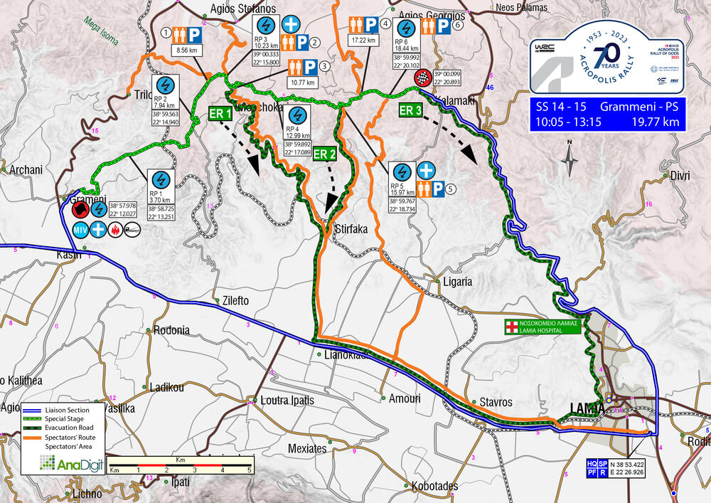
SUNDAY 10 SEPTEMBER
SS 14-15 GRAMMENI 1 + WOLF POWER STAGE
Length: 19.67 km
Timetable
Road closing time: SS 14 06:59
First car due: SS 14 10:05
First car due: SS 15 13:15 WOLF POWER STAGE
DESCRIPTION
Perhaps the most technical and demanding special stage of the event. It is mainly uphill, with a few downhill sections, relatively narrow (except for the last three kilometres), with many jumps, sometimes fast and sometimes slow. About halfway through it has a 540m tarmac section, and just before the finish there is an impressive double high jump, but unfortunately limited space for spectators.
After the Power Stage finish, the podium ceremony will take place in the Kalamaki village square, shortly after the stage Stop.
ENJOY THE RALLY!
On the following pages are the access roads that organisers have chosen for spectators. Next to the number of each access road, there is a letter indicating the difficulty of the road surface. These are:
- S= Soft= Passenger car (hatchback, sedan, etc.)
- M= Medium= SUV
- H= Hard= 4x4 or Enduro motorcycle
SPECTATORS ACCESS
1 (S)
Driving from Lamia to Karpenisi, reset the odometer at the village “Kastri”, where there is an entrance sign, and a speed limit sign “50”. In 700 m. turn diagonally right. In 2.20 km (there will be a police officer) continue straight ahead and in 500 m, where there is a chapel and a sign “Αρχάνι” (on the left) turn right, and immediately left. In 8,50 km is "Τρίλοφο". After 1.10 km, where there is a sign " Μοσχοκαρυά ", turn right on the gravel road. In 3,10 km you reach the 9,34 km of the SS.
The previous 800 m of the ss are spectacular, starting from a point (at 8.56 km) where the cars have to pass through a very narrow passage between two trees.
Click to navigate
SS 14-15 GRAMMENI ACCESS 1 (9.34km)
2 (S)
When approaching the village of Ag.Stefanos from the North, head East and reset your odometer at the sign for “Pepsi-Καφέ ψητοπωλείο του Συλλόγου”. After driving for 900 meters, take a right at the roundabout towards “Moschokarya”. Keep driving for 3.30 km until you reach the 10.23 km of the ss, where the road changes from gravel to tarmac. At this point, you will have two options.
A) Remain at the spot and watch the competitors descending a fast tarmac downhill section.
B) Provided the access road is not yet closed, turn left onto the gravel road. After 900 m. you will reach the 11.05 km.
Click to navigate
SS 14-15 GRAMMENI ACCESS 2 (10.23km)
3 (S)
Heading from Lamia to Karpenisi, reset the odometer and continue straight ahead at the roundabout in front of the Region of Central Greece building. At 5.70 km, at the roundabout, continue straight on towards Karpenisi. At 5.80 km, at the first traffic lights, continue straight ahead and in 100 m, at the second traffic lights (church on the right), turn right towards “Στίρφακα-Μοσχοκαρυά 10”. At 3,40 km you’ll see a sign “Στίρφακα” and at 600 m, where there is a sign "Μοσχοκαρυά", turn left. In 150 m, at the junction turn left towards “Μοσχοκαρυά 10”. In 10.35 km, at the junction turn right towards “Αγ. Στέφανος-Δομοκός”. In 600 m, where a house on the right, traffic will be blocked.
Turn around and park on one side of the road. In 100 m. you will find the 10.77 km of the stage.
Note: Park according to the marshals’ instructions. This is an ambulance evacuation route. Blocking it may cause the special stage to be cancelled.
Click to navigate
SS 14-15 GRAMMENI ACCESS 3 (10.77km)
4(M)
Heading from Lamia to Karpenisi, reset the odometer and continue straight ahead at the roundabout in front of the Region of Central Greece building. At 5.70 km, at the roundabout, continue straight on towards Karpenisi. At 5.80 km, at the first traffic lights, continue straight ahead and in 100 m, at the second traffic lights (church on the right), turn right towards “Στίρφακα-Μοσχοκαρυά 10”. At 3,40 km you’ll see a sign “Στίρφακα” and at 600 m, where there is a sign “Κοινωτικό κατάστημα Στίρφακας”, at the junction turn right. In 200 m, at the sign "Ι. Ναός Αναλήψεως" turn left. In 300 m, at the crossroads, turn right. In 250 m, you'll meet train tracks. After 250 m, at the junction, turn left. In 100 m, follow the road to the right under the bridge and turn left in 1 km, where there is a sign "Kalamaki”. In 5,70 km you reach 15,97 km of the stage.
Click to navigate
SS 14-15 GRAMMENI ACCESS 4 (15.97km)
5 (M)
Arriving from the North at the village of “Ag. Stefanos” and exiting the village East, reset the odometer at the sign " Pepsi-Καφέ ψητοπωλείο του Συλλόγου ". In 900 m., at the roundabout, continue straight on. In 2.20 km, at the crossroads to “Κορομηλιά” continue straight ahead. At 3.60 km, at the junction “Ξυνιάδα-Xyniada” turn right and after 200 m at “Stop” continue straight ahead. In 100 m, opposite a house and a mirror, turn right. Turn left in 400 m, where a wooden post is on the left. In 300 m, at the “T” junction, turn right and in another 100 m, at the fork turn left. In 1.20 km, at the fork, turn right and in 400 m, at the junction, turn left. At 1.10 km, at the beginning of the fence, although it does not look like a road, continue straight ahead and at 2.80 km turn left. In 1.30 km you’ll reach the 17.22 km of the stage.
No navigation to that spot.
6 (M)
Driving on the Lamia-Karpenissi road, keep an eye out for a sign directing you to “Λυγαριά”. Turn right at this sign and continue for 1.55 km until you reach a “Stop” sign. Turn left and travel 250 m until you reach a bridge. Just before the bridge, turn left. After 3.10 km, you will go under a high bridge and then turn right. At 2.90 km, leave the wider road and turn left onto a narrow gravel road. At 1.30 km, you will come across a road on the left, but continue straight. After 1.80 km, you'll encounter another gravel road on the left, but keep going straight. At the junction 600 m ahead, turn left. Finally, after 3.20 km, you'll arrive at a spectacular location at the 18.44 km of the stage.
Click to navigate
SS 14-15 GRAMMENI ACCESS 6 (18.44km)